You are here: Home > Network List > UW - Pacific Northwest Regional Seismic Network Stations List
> Station YACT Amboy, WA, USA > Earthquake Result Viewer
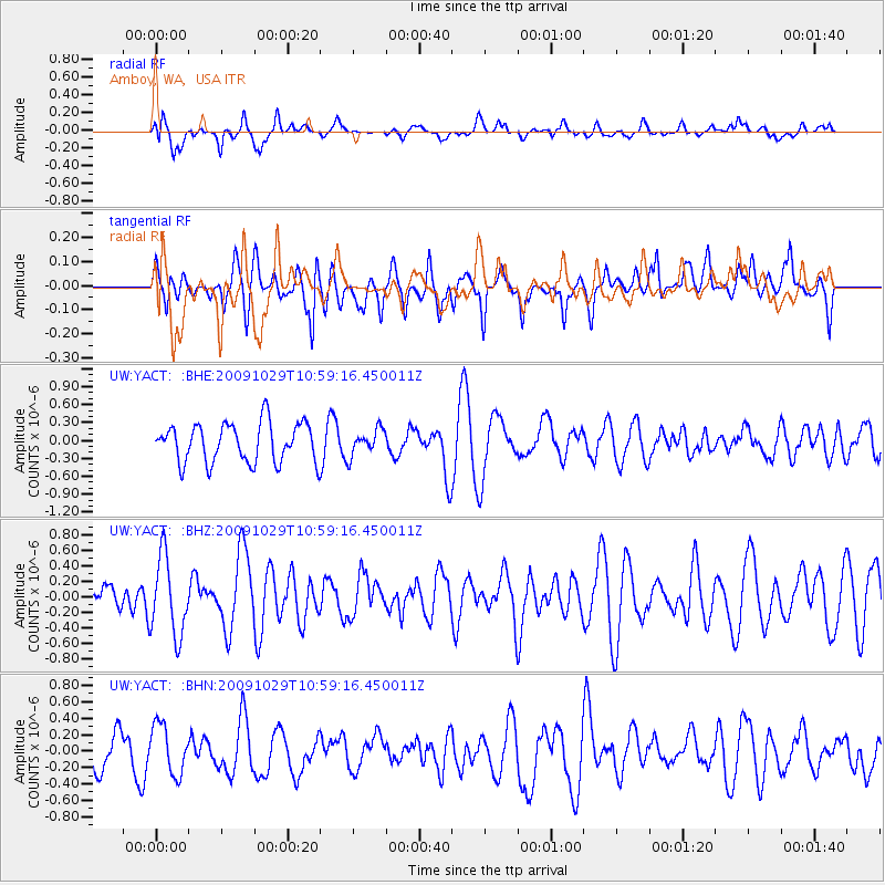
YACT Amboy, WA, USA - Earthquake Result Viewer
*The percent match for this event was below the threshold and hence no stack was calculated.
| Earthquake location: |
Veracruz, Mexico |
| Earthquake latitude/longitude: |
18.9/-95.5 |
| Earthquake time(UTC): |
2009/10/29 (302) 10:52:56 GMT |
| Earthquake Depth: |
16 km |
| Earthquake Magnitude: |
5.5 MB, 5.3 MS, 5.7 MW, 5.5 MD |
| Earthquake Catalog/Contributor: |
WHDF/NEIC |
|
| Network: |
UW Pacific Northwest Regional Seismic Network |
| Station: |
YACT Amboy, WA, USA |
| Lat/Lon: |
45.93 N/122.42 W |
| Elevation: |
211 m |
|
| Distance: |
34.9 deg |
| Az: |
326.539 deg |
| Baz: |
131.59 deg |
| Ray Param: |
$rayparam |
*The percent match for this event was below the threshold and hence was not used in the summary stack. |
|
| Radial Match: |
50.981365 % |
| Radial Bump: |
400 |
| Transverse Match: |
56.513527 % |
| Transverse Bump: |
400 |
| SOD ConfigId: |
2622 |
| Insert Time: |
2010-02-27 05:24:03.696 +0000 |
| GWidth: |
2.5 |
| Max Bumps: |
400 |
| Tol: |
0.001 |
|
Signal To Noise
| Channel | StoN | STA | LTA |
| UW:YACT: :BHZ:20091029T10:59:16.450011Z | 2.4221315 | 5.0625573E-7 | 2.090125E-7 |
| UW:YACT: :BHN:20091029T10:59:16.450011Z | 1.2363279 | 3.0146256E-7 | 2.4383706E-7 |
| UW:YACT: :BHE:20091029T10:59:16.450011Z | 0.6611842 | 2.156209E-7 | 3.2611322E-7 |
| Arrivals |
| Ps | |
| PpPs | |
| PsPs/PpSs | |


