You are here: Home > Network List > YB13 - Continental Dynamics/Cent. Anatolian Tectonics:Surface to Mantle Dynamics During Stations List
> Station AT05 Ormanici,Malatya,Turkey > Earthquake Result Viewer
AT05 Ormanici,Malatya,Turkey - Earthquake Result Viewer
| Earthquake location: |
Shikoku, Japan |
| Earthquake latitude/longitude: |
32.1/132.1 |
| Earthquake time(UTC): |
2014/08/28 (240) 19:14:35 GMT |
| Earthquake Depth: |
22 km |
| Earthquake Magnitude: |
5.8 MWB |
| Earthquake Catalog/Contributor: |
NEIC PDE/NEIC COMCAT |
|
| Network: |
YB Continental Dynamics/Cent. Anatolian Tectonics:Surface to Mantle Dynamics During |
| Station: |
AT05 Ormanici,Malatya,Turkey |
| Lat/Lon: |
38.22 N/38.79 E |
| Elevation: |
851 m |
|
| Distance: |
73.3 deg |
| Az: |
304.821 deg |
| Baz: |
62.208 deg |
| Ray Param: |
0.053062905 |
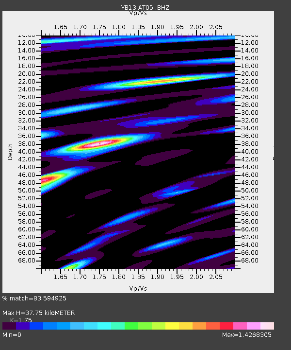
| Estimated Moho Depth: |
37.75 km |
| Estimated Crust Vp/Vs: |
1.75 |
| Assumed Crust Vp: |
6.35 km/s |
| Estimated Crust Vs: |
3.629 km/s |
| Estimated Crust Poisson's Ratio: |
0.26 |
|
| Radial Match: |
83.594925 % |
| Radial Bump: |
400 |
| Transverse Match: |
84.09026 % |
| Transverse Bump: |
400 |
| SOD ConfigId: |
3390531 |
| Insert Time: |
2019-04-13 16:47:32.256 +0000 |
| GWidth: |
2.5 |
| Max Bumps: |
400 |
| Tol: |
0.001 |
|

Signal To Noise
| Channel | StoN | STA | LTA |
| YB:AT05: :BHZ:20140828T19:25:34.259993Z | 23.441347 | 5.696864E-7 | 2.430263E-8 |
| YB:AT05: :BHN:20140828T19:25:34.259993Z | 2.4351435 | 7.7878134E-8 | 3.198092E-8 |
| YB:AT05: :BHE:20140828T19:25:34.259993Z | 8.585317 | 2.1172238E-7 | 2.4660986E-8 |
| Arrivals |
| Ps | 4.6 SECOND |
| PpPs | 16 SECOND |
| PsPs/PpSs | 20 SECOND |


