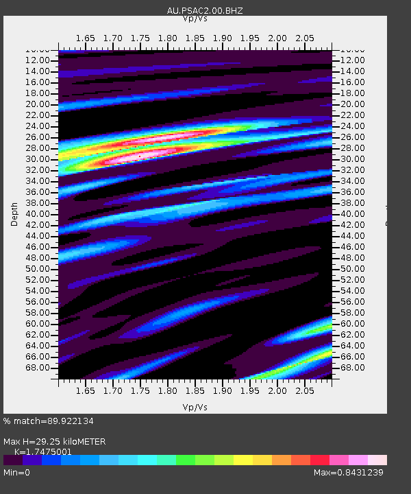
PSAC2 Pilbara Seismic Array Element C2 - Earthquake Result Viewer

Earthquake location: Myanmar
Earthquake latitude/longitude: 23.0/95.9
Earthquake time(UTC): 2012/11/11 (316) 01:12:38 GMT
Earthquake Depth: 14 km
Earthquake Magnitude: 6.8 MW, 6.3 MB, 6.7 MS, 6.8 MW
Earthquake Catalog/Contributor: NEIC PDE/NEIC PDE-W
Network: AU Australian Seismological Centre
Station: PSAC2 Pilbara Seismic Array Element C2
Lat/Lon: 21.56 S/119.90 E
Elevation: 330 m
Distance: 50.1 deg
Az: 150.407 deg
Baz: 330.737 deg
Ray Param: 0.068271294
Estimated Moho Depth: 29.25 km
Estimated Crust Vp/Vs: 1.75
Assumed Crust Vp: 6.464 km/s
Estimated Crust Vs: 3.699 km/s
Estimated Crust Poisson's Ratio: 0.26
Radial Match: 89.922134 %
Radial Bump: 400
Transverse Match: 69.736435 %
Transverse Bump: 400
SOD ConfigId: 558545
Insert Time: 2013-09-17 23:02:28.339 +0000
GWidth: 2.5
Max Bumps: 400
Tol: 0.001

Signal To Noise

ChannelStoNSTALTA
AU:PSAC2:00:BHZ:20121111T01:21:02.419011Z4.1248051.3403792E-63.2495575E-7
AU:PSAC2:00:BH1:20121111T01:21:02.419011Z1.15729122.5402622E-72.195007E-7
AU:PSAC2:00:BH2:20121111T01:21:02.419011Z2.84168868.101168E-72.850829E-7
Arrivals
Ps3.6 SECOND
PpPs12 SECOND
PsPs/PpSs15 SECOND