You are here: Home > Network List > II - Global Seismograph Network (GSN - IRIS/IDA) Stations List
> Station WRAB Tennant Creek, NT, Australia > Earthquake Result Viewer
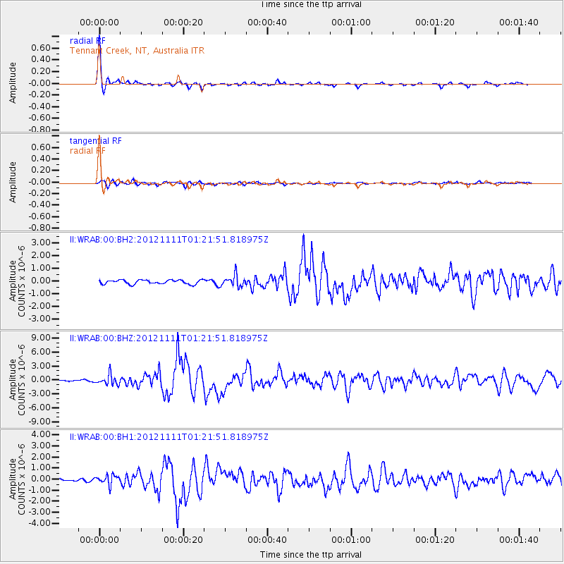
WRAB Tennant Creek, NT, Australia - Earthquake Result Viewer
| Earthquake location: |
Myanmar |
| Earthquake latitude/longitude: |
23.0/95.9 |
| Earthquake time(UTC): |
2012/11/11 (316) 01:12:38 GMT |
| Earthquake Depth: |
14 km |
| Earthquake Magnitude: |
6.8 MW, 6.3 MB, 6.7 MS, 6.8 MW |
| Earthquake Catalog/Contributor: |
NEIC PDE/NEIC PDE-W |
|
| Network: |
II Global Seismograph Network (GSN - IRIS/IDA) |
| Station: |
WRAB Tennant Creek, NT, Australia |
| Lat/Lon: |
19.93 S/134.36 E |
| Elevation: |
366 m |
|
| Distance: |
56.8 deg |
| Az: |
135.636 deg |
| Baz: |
316.781 deg |
| Ray Param: |
0.06386913 |
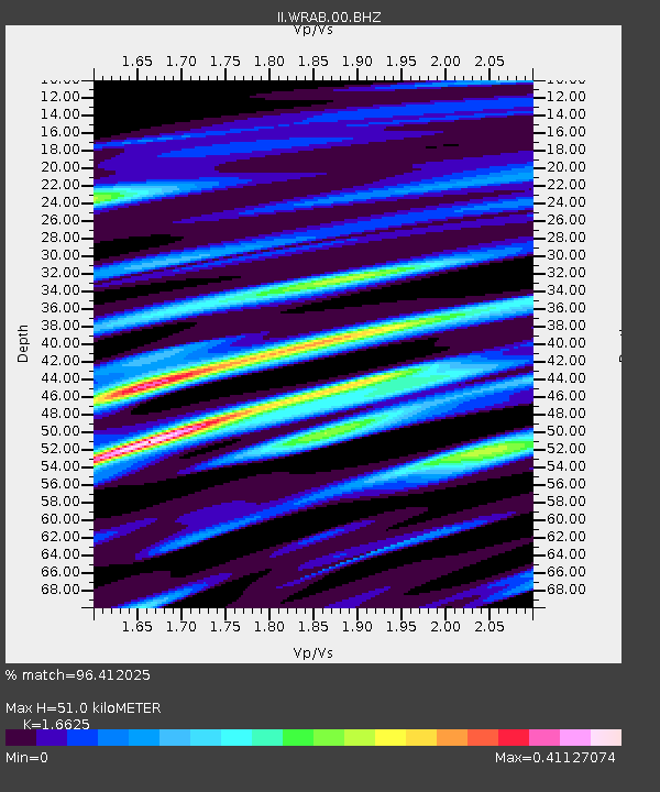
| Estimated Moho Depth: |
51.0 km |
| Estimated Crust Vp/Vs: |
1.66 |
| Assumed Crust Vp: |
6.642 km/s |
| Estimated Crust Vs: |
3.995 km/s |
| Estimated Crust Poisson's Ratio: |
0.22 |
|
| Radial Match: |
96.412025 % |
| Radial Bump: |
198 |
| Transverse Match: |
81.261665 % |
| Transverse Bump: |
400 |
| SOD ConfigId: |
558545 |
| Insert Time: |
2013-09-17 23:03:50.773 +0000 |
| GWidth: |
2.5 |
| Max Bumps: |
400 |
| Tol: |
0.001 |
|
Signal To Noise
| Channel | StoN | STA | LTA |
| II:WRAB:00:BHZ:20121111T01:21:51.818975Z | 5.2539787 | 1.0827457E-6 | 2.060811E-7 |
| II:WRAB:00:BH1:20121111T01:21:51.818975Z | 3.7621312 | 4.2873663E-7 | 1.1396111E-7 |
| II:WRAB:00:BH2:20121111T01:21:51.818975Z | 2.782569 | 4.4733906E-7 | 1.6076478E-7 |
| Arrivals |
| Ps | 5.4 SECOND |
| PpPs | 19 SECOND |
| PsPs/PpSs | 25 SECOND |


