You are here: Home > Network List > IU - Global Seismograph Network (GSN - IRIS/USGS) Stations List
> Station GNI Garni, Armenia > Earthquake Result Viewer
GNI Garni, Armenia - Earthquake Result Viewer
| Earthquake location: |
Myanmar |
| Earthquake latitude/longitude: |
23.0/95.9 |
| Earthquake time(UTC): |
2012/11/11 (316) 01:12:38 GMT |
| Earthquake Depth: |
14 km |
| Earthquake Magnitude: |
6.8 MW, 6.3 MB, 6.7 MS, 6.8 MW |
| Earthquake Catalog/Contributor: |
NEIC PDE/NEIC PDE-W |
|
| Network: |
IU Global Seismograph Network (GSN - IRIS/USGS) |
| Station: |
GNI Garni, Armenia |
| Lat/Lon: |
40.15 N/44.74 E |
| Elevation: |
1609 m |
|
| Distance: |
46.2 deg |
| Az: |
304.15 deg |
| Baz: |
95.84 deg |
| Ray Param: |
0.0708076 |
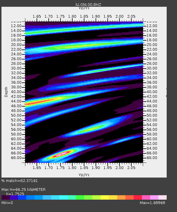
| Estimated Moho Depth: |
66.25 km |
| Estimated Crust Vp/Vs: |
1.75 |
| Assumed Crust Vp: |
6.291 km/s |
| Estimated Crust Vs: |
3.59 km/s |
| Estimated Crust Poisson's Ratio: |
0.26 |
|
| Radial Match: |
82.37161 % |
| Radial Bump: |
400 |
| Transverse Match: |
76.48568 % |
| Transverse Bump: |
400 |
| SOD ConfigId: |
558545 |
| Insert Time: |
2013-09-17 23:04:12.617 +0000 |
| GWidth: |
2.5 |
| Max Bumps: |
400 |
| Tol: |
0.001 |
|
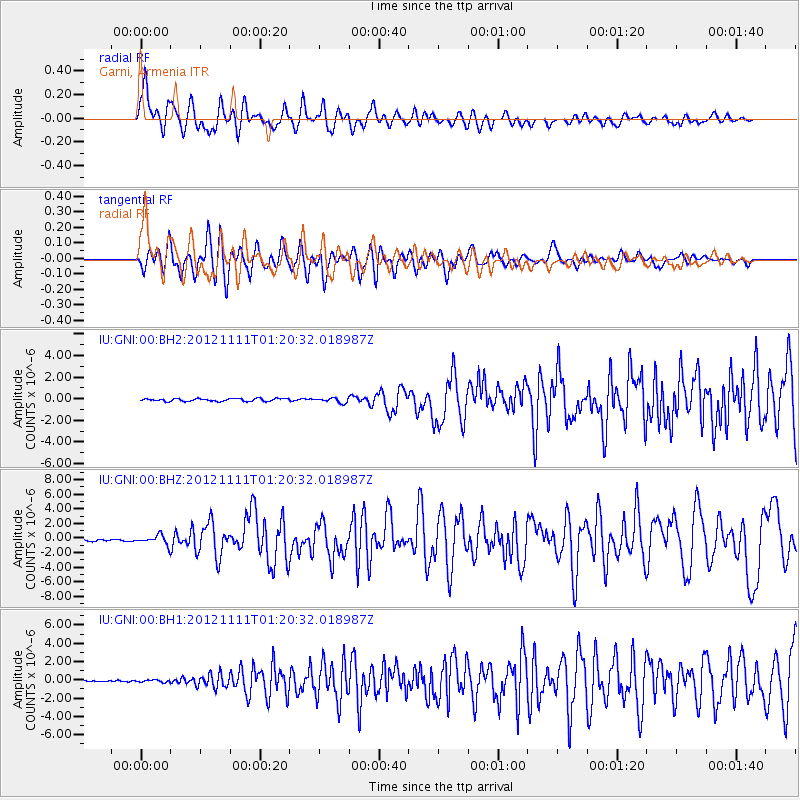
Signal To Noise
| Channel | StoN | STA | LTA |
| IU:GNI:00:BHZ:20121111T01:20:32.018987Z | 6.4764485 | 6.4218307E-7 | 9.9156665E-8 |
| IU:GNI:00:BH1:20121111T01:20:32.018987Z | 0.8401839 | 1.3021726E-7 | 1.5498661E-7 |
| IU:GNI:00:BH2:20121111T01:20:32.018987Z | 1.7813314 | 2.1847693E-7 | 1.226481E-7 |
| Arrivals |
| Ps | 8.4 SECOND |
| PpPs | 27 SECOND |
| PsPs/PpSs | 36 SECOND |


