You are here: Home > Network List > IU - Global Seismograph Network (GSN - IRIS/USGS) Stations List
> Station MAJO Matsushiro, Japan > Earthquake Result Viewer
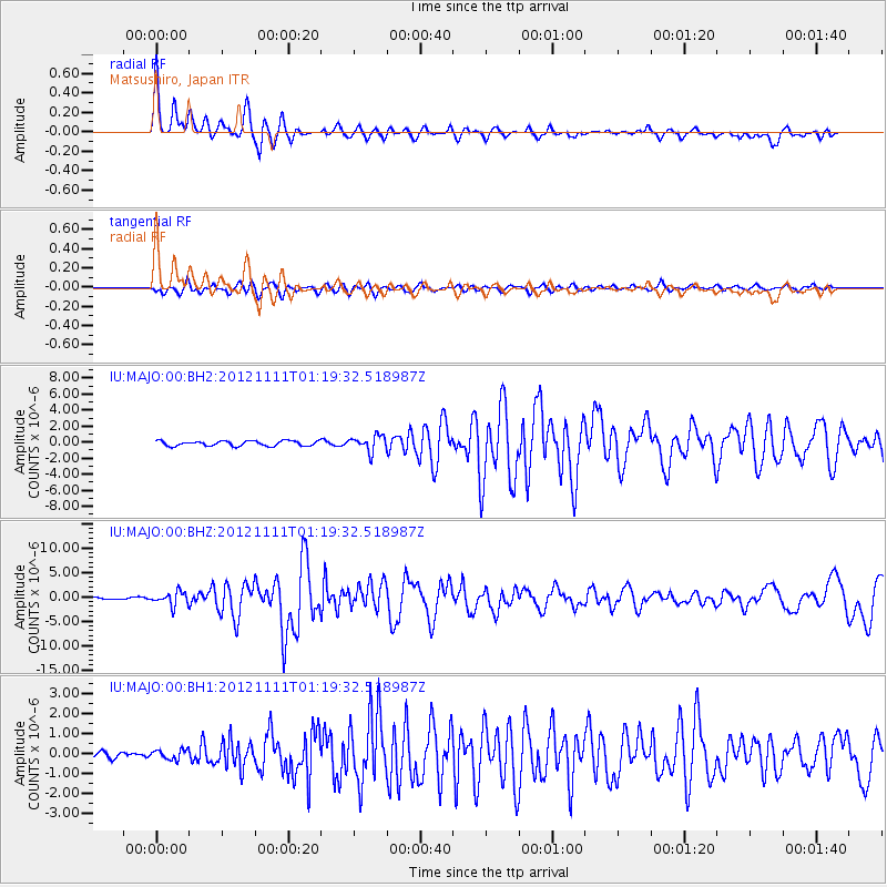
MAJO Matsushiro, Japan - Earthquake Result Viewer
*The percent match for this event was below the threshold and hence no stack was calculated.
| Earthquake location: |
Myanmar |
| Earthquake latitude/longitude: |
23.0/95.9 |
| Earthquake time(UTC): |
2012/11/11 (316) 01:12:38 GMT |
| Earthquake Depth: |
14 km |
| Earthquake Magnitude: |
6.8 MW, 6.3 MB, 6.7 MS, 6.8 MW |
| Earthquake Catalog/Contributor: |
NEIC PDE/NEIC PDE-W |
|
| Network: |
IU Global Seismograph Network (GSN - IRIS/USGS) |
| Station: |
MAJO Matsushiro, Japan |
| Lat/Lon: |
36.55 N/138.20 E |
| Elevation: |
405 m |
|
| Distance: |
38.8 deg |
| Az: |
59.851 deg |
| Baz: |
261.655 deg |
| Ray Param: |
$rayparam |
*The percent match for this event was below the threshold and hence was not used in the summary stack. |
|
| Radial Match: |
72.67997 % |
| Radial Bump: |
400 |
| Transverse Match: |
75.877716 % |
| Transverse Bump: |
400 |
| SOD ConfigId: |
558545 |
| Insert Time: |
2013-09-17 23:04:33.656 +0000 |
| GWidth: |
2.5 |
| Max Bumps: |
400 |
| Tol: |
0.001 |
|
Signal To Noise
| Channel | StoN | STA | LTA |
| IU:MAJO:00:BHZ:20121111T01:19:32.518987Z | 5.0324626 | 1.385234E-6 | 2.7525965E-7 |
| IU:MAJO:00:BH1:20121111T01:19:32.518987Z | 1.1453775 | 2.4772353E-7 | 2.1628112E-7 |
| IU:MAJO:00:BH2:20121111T01:19:32.518987Z | 3.1311846 | 9.789371E-7 | 3.1264116E-7 |
| Arrivals |
| Ps | |
| PpPs | |
| PsPs/PpSs | |


