You are here: Home > Network List > II - Global Seismograph Network (GSN - IRIS/IDA) Stations List
> Station WRAB Tennant Creek, NT, Australia > Earthquake Result Viewer
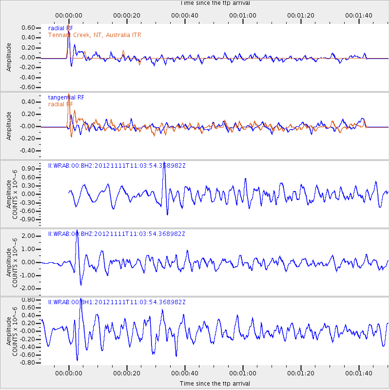
WRAB Tennant Creek, NT, Australia - Earthquake Result Viewer
*The percent match for this event was below the threshold and hence no stack was calculated.
| Earthquake location: |
Myanmar |
| Earthquake latitude/longitude: |
22.7/95.8 |
| Earthquake time(UTC): |
2012/11/11 (316) 10:54:41 GMT |
| Earthquake Depth: |
6.0 km |
| Earthquake Magnitude: |
5.8 MW, 5.7 MB, 5.7 MW, 5.8 MS |
| Earthquake Catalog/Contributor: |
NEIC PDE/NEIC PDE-W |
|
| Network: |
II Global Seismograph Network (GSN - IRIS/IDA) |
| Station: |
WRAB Tennant Creek, NT, Australia |
| Lat/Lon: |
19.93 S/134.36 E |
| Elevation: |
366 m |
|
| Distance: |
56.7 deg |
| Az: |
135.462 deg |
| Baz: |
316.502 deg |
| Ray Param: |
$rayparam |
*The percent match for this event was below the threshold and hence was not used in the summary stack. |
|
| Radial Match: |
58.506695 % |
| Radial Bump: |
400 |
| Transverse Match: |
72.000656 % |
| Transverse Bump: |
400 |
| SOD ConfigId: |
558545 |
| Insert Time: |
2013-09-17 23:06:31.624 +0000 |
| GWidth: |
2.5 |
| Max Bumps: |
400 |
| Tol: |
0.001 |
|
Signal To Noise
| Channel | StoN | STA | LTA |
| II:WRAB:00:BHZ:20121111T11:03:54.368982Z | 4.9544625 | 1.0456448E-6 | 2.110511E-7 |
| II:WRAB:00:BH1:20121111T11:03:54.368982Z | 2.0382047 | 3.9570594E-7 | 1.9414435E-7 |
| II:WRAB:00:BH2:20121111T11:03:54.368982Z | 2.2712288 | 4.813096E-7 | 2.1191596E-7 |
| Arrivals |
| Ps | |
| PpPs | |
| PsPs/PpSs | |


