You are here: Home > Network List > IU - Global Seismograph Network (GSN - IRIS/USGS) Stations List
> Station JOHN Johnston Island, USA > Earthquake Result Viewer
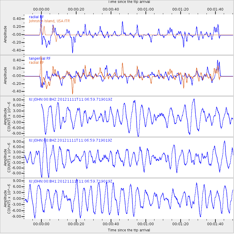
JOHN Johnston Island, USA - Earthquake Result Viewer
*The percent match for this event was below the threshold and hence no stack was calculated.
| Earthquake location: |
Myanmar |
| Earthquake latitude/longitude: |
22.7/95.8 |
| Earthquake time(UTC): |
2012/11/11 (316) 10:54:41 GMT |
| Earthquake Depth: |
6.0 km |
| Earthquake Magnitude: |
5.8 MW, 5.7 MB, 5.7 MW, 5.8 MS |
| Earthquake Catalog/Contributor: |
NEIC PDE/NEIC PDE-W |
|
| Network: |
IU Global Seismograph Network (GSN - IRIS/USGS) |
| Station: |
JOHN Johnston Island, USA |
| Lat/Lon: |
16.73 N/169.53 W |
| Elevation: |
2.0 m |
|
| Distance: |
87.8 deg |
| Az: |
72.892 deg |
| Baz: |
292.931 deg |
| Ray Param: |
$rayparam |
*The percent match for this event was below the threshold and hence was not used in the summary stack. |
|
| Radial Match: |
51.45722 % |
| Radial Bump: |
400 |
| Transverse Match: |
65.13235 % |
| Transverse Bump: |
400 |
| SOD ConfigId: |
558545 |
| Insert Time: |
2013-09-17 23:06:57.004 +0000 |
| GWidth: |
2.5 |
| Max Bumps: |
400 |
| Tol: |
0.001 |
|
Signal To Noise
| Channel | StoN | STA | LTA |
| IU:JOHN:00:BHZ:20121111T11:06:59.719019Z | 3.1653442 | 7.5674056E-6 | 2.3907053E-6 |
| IU:JOHN:00:BH1:20121111T11:06:59.719019Z | 1.4054586 | 4.142461E-6 | 2.9474088E-6 |
| IU:JOHN:00:BH2:20121111T11:06:59.719019Z | 0.39169532 | 1.71028E-6 | 4.3663526E-6 |
| Arrivals |
| Ps | |
| PpPs | |
| PsPs/PpSs | |


