You are here: Home > Network List > UW - Pacific Northwest Regional Seismic Network Stations List
> Station YACT Amboy, WA, USA > Earthquake Result Viewer
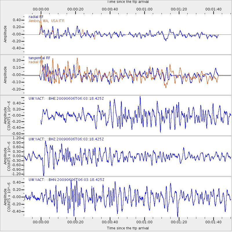
YACT Amboy, WA, USA - Earthquake Result Viewer
*The percent match for this event was below the threshold and hence no stack was calculated.
| Earthquake location: |
Near East Coast Of Honshu, Japan |
| Earthquake latitude/longitude: |
35.5/140.9 |
| Earthquake time(UTC): |
2009/06/06 (157) 05:52:43 GMT |
| Earthquake Depth: |
34 km |
| Earthquake Magnitude: |
5.8 MB, 5.4 MS, 5.8 MW, 5.7 MW |
| Earthquake Catalog/Contributor: |
WHDF/NEIC |
|
| Network: |
UW Pacific Northwest Regional Seismic Network |
| Station: |
YACT Amboy, WA, USA |
| Lat/Lon: |
45.93 N/122.42 W |
| Elevation: |
211 m |
|
| Distance: |
69.7 deg |
| Az: |
47.675 deg |
| Baz: |
300.167 deg |
| Ray Param: |
$rayparam |
*The percent match for this event was below the threshold and hence was not used in the summary stack. |
|
| Radial Match: |
68.37135 % |
| Radial Bump: |
400 |
| Transverse Match: |
71.33424 % |
| Transverse Bump: |
400 |
| SOD ConfigId: |
2648 |
| Insert Time: |
2010-02-27 05:24:16.588 +0000 |
| GWidth: |
2.5 |
| Max Bumps: |
400 |
| Tol: |
0.001 |
|
Signal To Noise
| Channel | StoN | STA | LTA |
| UW:YACT: :BHZ:20090606T06:03:18.425Z | 5.7603498 | 5.97572E-7 | 1.03738834E-7 |
| UW:YACT: :BHN:20090606T06:03:18.425Z | 0.99259126 | 9.6648385E-8 | 9.736977E-8 |
| UW:YACT: :BHE:20090606T06:03:18.425Z | 1.9798293 | 2.0253425E-7 | 1.0229885E-7 |
| Arrivals |
| Ps | |
| PpPs | |
| PsPs/PpSs | |


