You are here: Home > Network List > II - Global Seismograph Network (GSN - IRIS/IDA) Stations List
> Station KAPI Kappang, Sulawesi, Indonesia > Earthquake Result Viewer
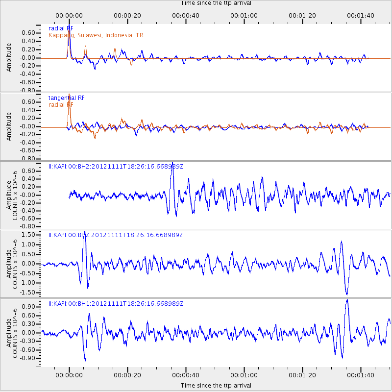
KAPI Kappang, Sulawesi, Indonesia - Earthquake Result Viewer
*The percent match for this event was below the threshold and hence no stack was calculated.
| Earthquake location: |
Myanmar |
| Earthquake latitude/longitude: |
23.1/95.9 |
| Earthquake time(UTC): |
2012/11/11 (316) 18:19:45 GMT |
| Earthquake Depth: |
28 km |
| Earthquake Magnitude: |
5.5 MW, 5.5 MB, 5.5 MW |
| Earthquake Catalog/Contributor: |
NEIC PDE/NEIC PDE-W |
|
| Network: |
II Global Seismograph Network (GSN - IRIS/IDA) |
| Station: |
KAPI Kappang, Sulawesi, Indonesia |
| Lat/Lon: |
5.01 S/119.75 E |
| Elevation: |
300 m |
|
| Distance: |
36.4 deg |
| Az: |
137.208 deg |
| Baz: |
321.117 deg |
| Ray Param: |
$rayparam |
*The percent match for this event was below the threshold and hence was not used in the summary stack. |
|
| Radial Match: |
71.77613 % |
| Radial Bump: |
347 |
| Transverse Match: |
55.116177 % |
| Transverse Bump: |
400 |
| SOD ConfigId: |
558545 |
| Insert Time: |
2013-09-17 23:08:12.509 +0000 |
| GWidth: |
2.5 |
| Max Bumps: |
400 |
| Tol: |
0.001 |
|
Signal To Noise
| Channel | StoN | STA | LTA |
| II:KAPI:00:BHZ:20121111T18:26:16.668989Z | 6.446875 | 4.170899E-7 | 6.4696444E-8 |
| II:KAPI:00:BH1:20121111T18:26:16.668989Z | 1.6300579 | 1.3317464E-7 | 8.1699326E-8 |
| II:KAPI:00:BH2:20121111T18:26:16.668989Z | 3.5191875 | 1.7719225E-7 | 5.0350334E-8 |
| Arrivals |
| Ps | |
| PpPs | |
| PsPs/PpSs | |


