You are here: Home > Network List > IU - Global Seismograph Network (GSN - IRIS/USGS) Stations List
> Station GNI Garni, Armenia > Earthquake Result Viewer
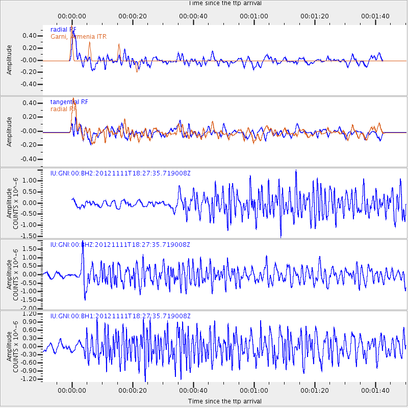
GNI Garni, Armenia - Earthquake Result Viewer
*The percent match for this event was below the threshold and hence no stack was calculated.
| Earthquake location: |
Myanmar |
| Earthquake latitude/longitude: |
23.1/95.9 |
| Earthquake time(UTC): |
2012/11/11 (316) 18:19:45 GMT |
| Earthquake Depth: |
28 km |
| Earthquake Magnitude: |
5.5 MW, 5.5 MB, 5.5 MW |
| Earthquake Catalog/Contributor: |
NEIC PDE/NEIC PDE-W |
|
| Network: |
IU Global Seismograph Network (GSN - IRIS/USGS) |
| Station: |
GNI Garni, Armenia |
| Lat/Lon: |
40.15 N/44.74 E |
| Elevation: |
1609 m |
|
| Distance: |
46.1 deg |
| Az: |
304.051 deg |
| Baz: |
95.708 deg |
| Ray Param: |
$rayparam |
*The percent match for this event was below the threshold and hence was not used in the summary stack. |
|
| Radial Match: |
63.771973 % |
| Radial Bump: |
400 |
| Transverse Match: |
52.441547 % |
| Transverse Bump: |
400 |
| SOD ConfigId: |
558545 |
| Insert Time: |
2013-09-17 23:08:49.065 +0000 |
| GWidth: |
2.5 |
| Max Bumps: |
400 |
| Tol: |
0.001 |
|
Signal To Noise
| Channel | StoN | STA | LTA |
| IU:GNI:00:BHZ:20121111T18:27:35.719008Z | 5.664006 | 6.9971895E-7 | 1.2353782E-7 |
| IU:GNI:00:BH1:20121111T18:27:35.719008Z | 1.37426 | 1.9875546E-7 | 1.4462726E-7 |
| IU:GNI:00:BH2:20121111T18:27:35.719008Z | 1.4064486 | 1.6978505E-7 | 1.20719E-7 |
| Arrivals |
| Ps | |
| PpPs | |
| PsPs/PpSs | |


