You are here: Home > Network List > II - Global Seismograph Network (GSN - IRIS/IDA) Stations List
> Station CMLA Cha de Macela, Sao Miguel Island, Azores > Earthquake Result Viewer
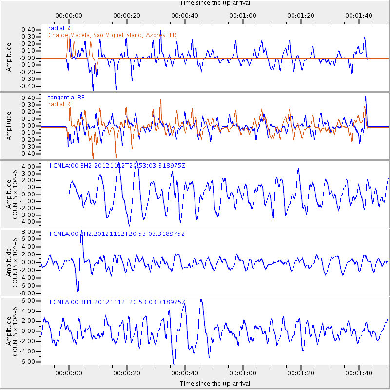
CMLA Cha de Macela, Sao Miguel Island, Azores - Earthquake Result Viewer
*The percent match for this event was below the threshold and hence no stack was calculated.
| Earthquake location: |
Gulf Of Alaska |
| Earthquake latitude/longitude: |
57.8/-142.9 |
| Earthquake time(UTC): |
2012/11/12 (317) 20:42:14 GMT |
| Earthquake Depth: |
9.0 km |
| Earthquake Magnitude: |
6.3 MW, 6.0 MB, 6.2 MS, 6.3 MW |
| Earthquake Catalog/Contributor: |
NEIC PDE/NEIC PDE-W |
|
| Network: |
II Global Seismograph Network (GSN - IRIS/IDA) |
| Station: |
CMLA Cha de Macela, Sao Miguel Island, Azores |
| Lat/Lon: |
37.76 N/25.52 W |
| Elevation: |
429 m |
|
| Distance: |
71.3 deg |
| Az: |
48.002 deg |
| Baz: |
329.854 deg |
| Ray Param: |
$rayparam |
*The percent match for this event was below the threshold and hence was not used in the summary stack. |
|
| Radial Match: |
63.059036 % |
| Radial Bump: |
400 |
| Transverse Match: |
49.54275 % |
| Transverse Bump: |
375 |
| SOD ConfigId: |
558545 |
| Insert Time: |
2013-09-17 23:12:20.099 +0000 |
| GWidth: |
2.5 |
| Max Bumps: |
400 |
| Tol: |
0.001 |
|
Signal To Noise
| Channel | StoN | STA | LTA |
| II:CMLA:00:BHZ:20121112T20:53:03.318975Z | 4.799411 | 4.1122375E-6 | 8.568214E-7 |
| II:CMLA:00:BH1:20121112T20:53:03.318975Z | 0.8564358 | 1.4214821E-6 | 1.6597648E-6 |
| II:CMLA:00:BH2:20121112T20:53:03.318975Z | 0.6628703 | 1.4569698E-6 | 2.197971E-6 |
| Arrivals |
| Ps | |
| PpPs | |
| PsPs/PpSs | |


