You are here: Home > Network List > IU - Global Seismograph Network (GSN - IRIS/USGS) Stations List
> Station PAYG Puerto Ayora, Galapagos Islands > Earthquake Result Viewer
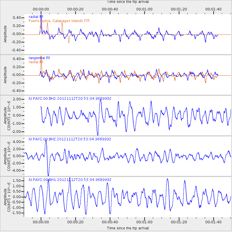
PAYG Puerto Ayora, Galapagos Islands - Earthquake Result Viewer
*The percent match for this event was below the threshold and hence no stack was calculated.
| Earthquake location: |
Gulf Of Alaska |
| Earthquake latitude/longitude: |
57.8/-142.9 |
| Earthquake time(UTC): |
2012/11/12 (317) 20:42:14 GMT |
| Earthquake Depth: |
9.0 km |
| Earthquake Magnitude: |
6.3 MW, 6.0 MB, 6.2 MS, 6.3 MW |
| Earthquake Catalog/Contributor: |
NEIC PDE/NEIC PDE-W |
|
| Network: |
IU Global Seismograph Network (GSN - IRIS/USGS) |
| Station: |
PAYG Puerto Ayora, Galapagos Islands |
| Lat/Lon: |
0.67 S/90.29 W |
| Elevation: |
270 m |
|
| Distance: |
71.6 deg |
| Az: |
123.196 deg |
| Baz: |
333.372 deg |
| Ray Param: |
$rayparam |
*The percent match for this event was below the threshold and hence was not used in the summary stack. |
|
| Radial Match: |
71.19357 % |
| Radial Bump: |
341 |
| Transverse Match: |
48.2906 % |
| Transverse Bump: |
361 |
| SOD ConfigId: |
558545 |
| Insert Time: |
2013-09-17 23:14:03.012 +0000 |
| GWidth: |
2.5 |
| Max Bumps: |
400 |
| Tol: |
0.001 |
|
Signal To Noise
| Channel | StoN | STA | LTA |
| IU:PAYG:00:BHZ:20121112T20:53:04.968999Z | 3.0076802 | 2.6778305E-6 | 8.9033085E-7 |
| IU:PAYG:00:BH1:20121112T20:53:04.968999Z | 1.1668103 | 9.944698E-7 | 8.522978E-7 |
| IU:PAYG:00:BH2:20121112T20:53:04.968999Z | 2.1391318 | 1.207632E-6 | 5.6454303E-7 |
| Arrivals |
| Ps | |
| PpPs | |
| PsPs/PpSs | |


