You are here: Home > Network List > IU - Global Seismograph Network (GSN - IRIS/USGS) Stations List
> Station SDV Santo Domingo, Venezuela > Earthquake Result Viewer
SDV Santo Domingo, Venezuela - Earthquake Result Viewer
| Earthquake location: |
Gulf Of Alaska |
| Earthquake latitude/longitude: |
57.8/-142.9 |
| Earthquake time(UTC): |
2012/11/12 (317) 20:42:14 GMT |
| Earthquake Depth: |
9.0 km |
| Earthquake Magnitude: |
6.3 MW, 6.0 MB, 6.2 MS, 6.3 MW |
| Earthquake Catalog/Contributor: |
NEIC PDE/NEIC PDE-W |
|
| Network: |
IU Global Seismograph Network (GSN - IRIS/USGS) |
| Station: |
SDV Santo Domingo, Venezuela |
| Lat/Lon: |
8.88 N/70.63 W |
| Elevation: |
1620 m |
|
| Distance: |
73.1 deg |
| Az: |
100.397 deg |
| Baz: |
327.786 deg |
| Ray Param: |
0.053246096 |
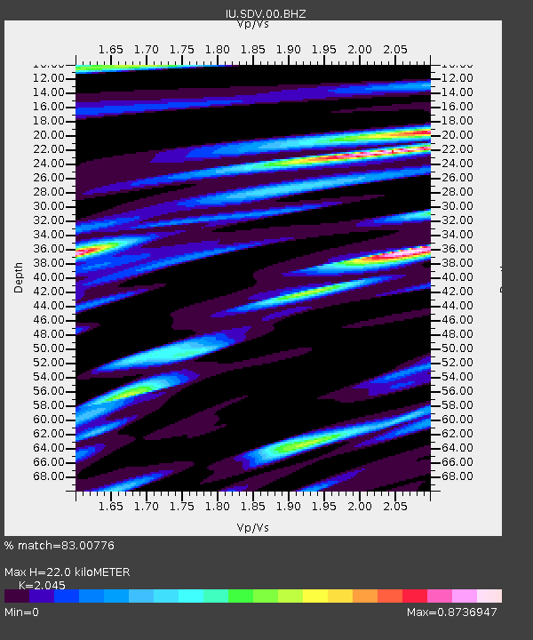
| Estimated Moho Depth: |
22.0 km |
| Estimated Crust Vp/Vs: |
2.05 |
| Assumed Crust Vp: |
6.192 km/s |
| Estimated Crust Vs: |
3.028 km/s |
| Estimated Crust Poisson's Ratio: |
0.34 |
|
| Radial Match: |
83.00776 % |
| Radial Bump: |
400 |
| Transverse Match: |
63.81244 % |
| Transverse Bump: |
400 |
| SOD ConfigId: |
558545 |
| Insert Time: |
2013-09-17 23:14:25.043 +0000 |
| GWidth: |
2.5 |
| Max Bumps: |
400 |
| Tol: |
0.001 |
|

Signal To Noise
| Channel | StoN | STA | LTA |
| IU:SDV:00:BHZ:20121112T20:53:13.718999Z | 5.759547 | 6.3266765E-7 | 1.0984677E-7 |
| IU:SDV:00:BH1:20121112T20:53:13.718999Z | 3.4370646 | 2.2709143E-7 | 6.607133E-8 |
| IU:SDV:00:BH2:20121112T20:53:13.718999Z | 2.2672052 | 1.1982448E-7 | 5.2851185E-8 |
| Arrivals |
| Ps | 3.8 SECOND |
| PpPs | 11 SECOND |
| PsPs/PpSs | 14 SECOND |


