You are here: Home > Network List > IU - Global Seismograph Network (GSN - IRIS/USGS) Stations List
> Station TEIG Tepich, Yucatan, Mexico > Earthquake Result Viewer
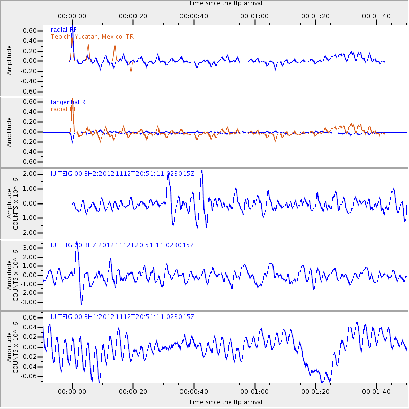
TEIG Tepich, Yucatan, Mexico - Earthquake Result Viewer
*The percent match for this event was below the threshold and hence no stack was calculated.
| Earthquake location: |
Gulf Of Alaska |
| Earthquake latitude/longitude: |
57.8/-142.9 |
| Earthquake time(UTC): |
2012/11/12 (317) 20:42:14 GMT |
| Earthquake Depth: |
9.0 km |
| Earthquake Magnitude: |
6.3 MW, 6.0 MB, 6.2 MS, 6.3 MW |
| Earthquake Catalog/Contributor: |
NEIC PDE/NEIC PDE-W |
|
| Network: |
IU Global Seismograph Network (GSN - IRIS/USGS) |
| Station: |
TEIG Tepich, Yucatan, Mexico |
| Lat/Lon: |
20.23 N/88.28 W |
| Elevation: |
40 m |
|
| Distance: |
54.4 deg |
| Az: |
109.804 deg |
| Baz: |
327.55 deg |
| Ray Param: |
$rayparam |
*The percent match for this event was below the threshold and hence was not used in the summary stack. |
|
| Radial Match: |
71.9474 % |
| Radial Bump: |
400 |
| Transverse Match: |
72.16708 % |
| Transverse Bump: |
365 |
| SOD ConfigId: |
558545 |
| Insert Time: |
2013-09-17 23:14:37.271 +0000 |
| GWidth: |
2.5 |
| Max Bumps: |
400 |
| Tol: |
0.001 |
|
Signal To Noise
| Channel | StoN | STA | LTA |
| IU:TEIG:00:BHZ:20121112T20:51:11.023015Z | 5.0708165 | 1.8023361E-6 | 3.5543312E-7 |
| IU:TEIG:00:BH1:20121112T20:51:11.023015Z | 1.4136778 | 3.501362E-8 | 2.4767752E-8 |
| IU:TEIG:00:BH2:20121112T20:51:11.023015Z | 4.0952578 | 9.818932E-7 | 2.397635E-7 |
| Arrivals |
| Ps | |
| PpPs | |
| PsPs/PpSs | |


