You are here: Home > Network List > US - United States National Seismic Network Stations List
> Station EYMN Ely, Minnesota, USA > Earthquake Result Viewer
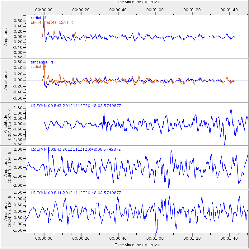
EYMN Ely, Minnesota, USA - Earthquake Result Viewer
*The percent match for this event was below the threshold and hence no stack was calculated.
| Earthquake location: |
Gulf Of Alaska |
| Earthquake latitude/longitude: |
57.8/-142.9 |
| Earthquake time(UTC): |
2012/11/12 (317) 20:42:14 GMT |
| Earthquake Depth: |
9.0 km |
| Earthquake Magnitude: |
6.3 MW, 6.0 MB, 6.2 MS, 6.3 MW |
| Earthquake Catalog/Contributor: |
NEIC PDE/NEIC PDE-W |
|
| Network: |
US United States National Seismic Network |
| Station: |
EYMN Ely, Minnesota, USA |
| Lat/Lon: |
47.95 N/91.50 W |
| Elevation: |
475 m |
|
| Distance: |
31.8 deg |
| Az: |
85.434 deg |
| Baz: |
307.432 deg |
| Ray Param: |
$rayparam |
*The percent match for this event was below the threshold and hence was not used in the summary stack. |
|
| Radial Match: |
68.10145 % |
| Radial Bump: |
400 |
| Transverse Match: |
63.221912 % |
| Transverse Bump: |
400 |
| SOD ConfigId: |
558545 |
| Insert Time: |
2013-09-17 23:15:50.053 +0000 |
| GWidth: |
2.5 |
| Max Bumps: |
400 |
| Tol: |
0.001 |
|
Signal To Noise
| Channel | StoN | STA | LTA |
| US:EYMN:00:BHZ:20121112T20:48:08.574987Z | 2.1644454 | 7.180943E-7 | 3.317683E-7 |
| US:EYMN:00:BH1:20121112T20:48:08.574987Z | 0.99455976 | 3.2410284E-7 | 3.258757E-7 |
| US:EYMN:00:BH2:20121112T20:48:08.574987Z | 1.7212318 | 3.728882E-7 | 2.166403E-7 |
| Arrivals |
| Ps | |
| PpPs | |
| PsPs/PpSs | |


