You are here: Home > Network List > UW - Pacific Northwest Regional Seismic Network Stations List
> Station YACT Amboy, WA, USA > Earthquake Result Viewer
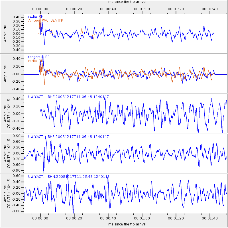
YACT Amboy, WA, USA - Earthquake Result Viewer
*The percent match for this event was below the threshold and hence no stack was calculated.
| Earthquake location: |
Fiji Islands Region |
| Earthquake latitude/longitude: |
-17.7/-178.4 |
| Earthquake time(UTC): |
2008/12/17 (352) 10:55:59 GMT |
| Earthquake Depth: |
530 km |
| Earthquake Magnitude: |
5.8 MW, 5.2 MB, 5.8 MW |
| Earthquake Catalog/Contributor: |
WHDF/NEIC |
|
| Network: |
UW Pacific Northwest Regional Seismic Network |
| Station: |
YACT Amboy, WA, USA |
| Lat/Lon: |
45.93 N/122.42 W |
| Elevation: |
211 m |
|
| Distance: |
81.1 deg |
| Az: |
35.83 deg |
| Baz: |
233.069 deg |
| Ray Param: |
$rayparam |
*The percent match for this event was below the threshold and hence was not used in the summary stack. |
|
| Radial Match: |
61.68657 % |
| Radial Bump: |
400 |
| Transverse Match: |
57.330917 % |
| Transverse Bump: |
400 |
| SOD ConfigId: |
2658 |
| Insert Time: |
2010-02-27 05:24:43.798 +0000 |
| GWidth: |
2.5 |
| Max Bumps: |
400 |
| Tol: |
0.001 |
|
Signal To Noise
| Channel | StoN | STA | LTA |
| UW:YACT: :BHZ:20081217T11:06:48.124011Z | 2.1151857 | 4.3976945E-7 | 2.0791057E-7 |
| UW:YACT: :BHN:20081217T11:06:48.124011Z | 0.66551715 | 1.4893082E-7 | 2.237821E-7 |
| UW:YACT: :BHE:20081217T11:06:48.124011Z | 0.91588724 | 1.4865861E-7 | 1.6231105E-7 |
| Arrivals |
| Ps | |
| PpPs | |
| PsPs/PpSs | |


