You are here: Home > Network List > IU - Global Seismograph Network (GSN - IRIS/USGS) Stations List
> Station CTAO Charters Towers, Australia > Earthquake Result Viewer
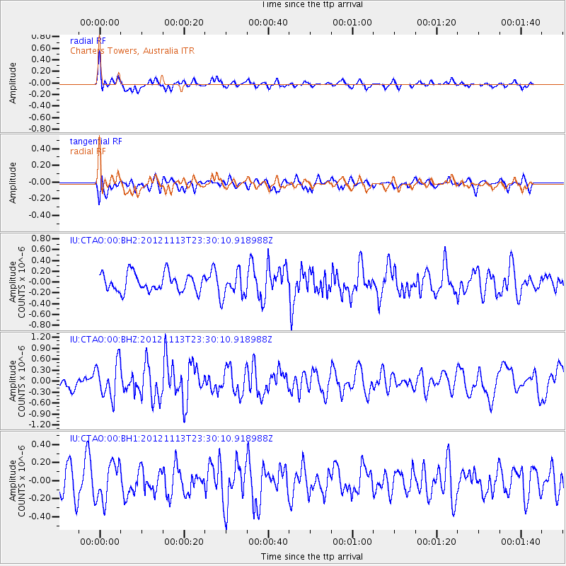
CTAO Charters Towers, Australia - Earthquake Result Viewer
*The percent match for this event was below the threshold and hence no stack was calculated.
| Earthquake location: |
Tonga Islands |
| Earthquake latitude/longitude: |
-21.0/-175.9 |
| Earthquake time(UTC): |
2012/11/13 (318) 23:23:48 GMT |
| Earthquake Depth: |
24 km |
| Earthquake Magnitude: |
5.6 MW |
| Earthquake Catalog/Contributor: |
NEIC PDE/NEIC PDE-W |
|
| Network: |
IU Global Seismograph Network (GSN - IRIS/USGS) |
| Station: |
CTAO Charters Towers, Australia |
| Lat/Lon: |
20.09 S/146.25 E |
| Elevation: |
357 m |
|
| Distance: |
35.4 deg |
| Az: |
264.659 deg |
| Baz: |
98.3 deg |
| Ray Param: |
$rayparam |
*The percent match for this event was below the threshold and hence was not used in the summary stack. |
|
| Radial Match: |
66.07964 % |
| Radial Bump: |
400 |
| Transverse Match: |
57.206234 % |
| Transverse Bump: |
400 |
| SOD ConfigId: |
558545 |
| Insert Time: |
2013-09-17 23:21:48.496 +0000 |
| GWidth: |
2.5 |
| Max Bumps: |
400 |
| Tol: |
0.001 |
|
Signal To Noise
| Channel | StoN | STA | LTA |
| IU:CTAO:00:BHZ:20121113T23:30:10.918988Z | 1.7517264 | 4.8959515E-7 | 2.7949292E-7 |
| IU:CTAO:00:BH1:20121113T23:30:10.918988Z | 0.99443305 | 2.0816766E-7 | 2.0933301E-7 |
| IU:CTAO:00:BH2:20121113T23:30:10.918988Z | 1.3644977 | 2.243921E-7 | 1.6445034E-7 |
| Arrivals |
| Ps | |
| PpPs | |
| PsPs/PpSs | |


