You are here: Home > Network List > US - United States National Seismic Network Stations List
> Station MNTX Cornudas Mountains, Texas, USA > Earthquake Result Viewer
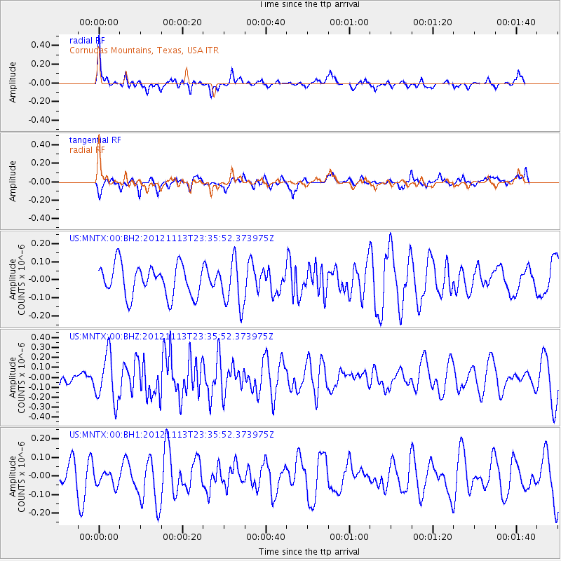
MNTX Cornudas Mountains, Texas, USA - Earthquake Result Viewer
*The percent match for this event was below the threshold and hence no stack was calculated.
| Earthquake location: |
Tonga Islands |
| Earthquake latitude/longitude: |
-21.0/-175.9 |
| Earthquake time(UTC): |
2012/11/13 (318) 23:23:48 GMT |
| Earthquake Depth: |
24 km |
| Earthquake Magnitude: |
5.6 MW |
| Earthquake Catalog/Contributor: |
NEIC PDE/NEIC PDE-W |
|
| Network: |
US United States National Seismic Network |
| Station: |
MNTX Cornudas Mountains, Texas, USA |
| Lat/Lon: |
31.70 N/105.38 W |
| Elevation: |
404 m |
|
| Distance: |
85.5 deg |
| Az: |
53.731 deg |
| Baz: |
242.072 deg |
| Ray Param: |
$rayparam |
*The percent match for this event was below the threshold and hence was not used in the summary stack. |
|
| Radial Match: |
49.123493 % |
| Radial Bump: |
385 |
| Transverse Match: |
51.326572 % |
| Transverse Bump: |
400 |
| SOD ConfigId: |
558545 |
| Insert Time: |
2013-09-17 23:23:17.727 +0000 |
| GWidth: |
2.5 |
| Max Bumps: |
400 |
| Tol: |
0.001 |
|
Signal To Noise
| Channel | StoN | STA | LTA |
| US:MNTX:00:BHZ:20121113T23:35:52.373975Z | 3.4705982 | 2.432065E-7 | 7.007625E-8 |
| US:MNTX:00:BH1:20121113T23:35:52.373975Z | 0.677721 | 3.984327E-8 | 5.8790068E-8 |
| US:MNTX:00:BH2:20121113T23:35:52.373975Z | 1.5016483 | 1.290656E-7 | 8.594928E-8 |
| Arrivals |
| Ps | |
| PpPs | |
| PsPs/PpSs | |


