You are here: Home > Network List > US - United States National Seismic Network Stations List
> Station OGNE Ogallala, Nebraska, USA > Earthquake Result Viewer
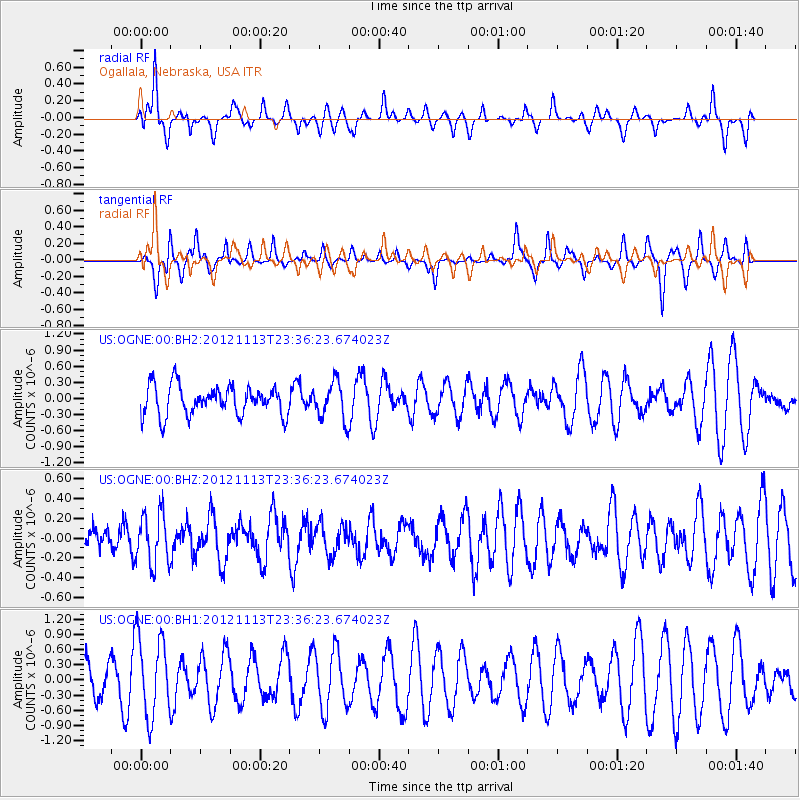
OGNE Ogallala, Nebraska, USA - Earthquake Result Viewer
*The percent match for this event was below the threshold and hence no stack was calculated.
| Earthquake location: |
Tonga Islands |
| Earthquake latitude/longitude: |
-21.0/-175.9 |
| Earthquake time(UTC): |
2012/11/13 (318) 23:23:48 GMT |
| Earthquake Depth: |
24 km |
| Earthquake Magnitude: |
5.6 MW |
| Earthquake Catalog/Contributor: |
NEIC PDE/NEIC PDE-W |
|
| Network: |
US United States National Seismic Network |
| Station: |
OGNE Ogallala, Nebraska, USA |
| Lat/Lon: |
40.95 N/102.03 W |
| Elevation: |
0.0 m |
|
| Distance: |
92.1 deg |
| Az: |
46.744 deg |
| Baz: |
243.908 deg |
| Ray Param: |
$rayparam |
*The percent match for this event was below the threshold and hence was not used in the summary stack. |
|
| Radial Match: |
46.64928 % |
| Radial Bump: |
307 |
| Transverse Match: |
36.45997 % |
| Transverse Bump: |
217 |
| SOD ConfigId: |
558545 |
| Insert Time: |
2013-09-17 23:23:27.810 +0000 |
| GWidth: |
2.5 |
| Max Bumps: |
400 |
| Tol: |
0.001 |
|
Signal To Noise
| Channel | StoN | STA | LTA |
| US:OGNE:00:BHZ:20121113T23:36:23.674023Z | 1.25505 | 2.5680743E-7 | 2.046193E-7 |
| US:OGNE:00:BH1:20121113T23:36:23.674023Z | 2.0857372 | 7.988983E-7 | 3.8302923E-7 |
| US:OGNE:00:BH2:20121113T23:36:23.674023Z | 1.2789823 | 3.553067E-7 | 2.7780422E-7 |
| Arrivals |
| Ps | |
| PpPs | |
| PsPs/PpSs | |


