You are here: Home > Network List > UW - Pacific Northwest Regional Seismic Network Stations List
> Station YACT Amboy, WA, USA > Earthquake Result Viewer
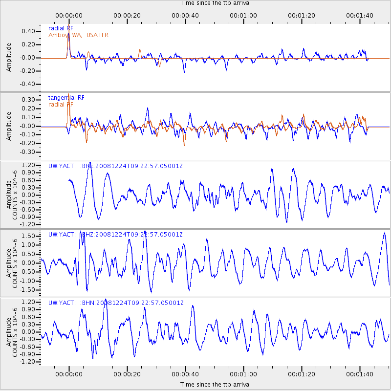
YACT Amboy, WA, USA - Earthquake Result Viewer
*The percent match for this event was below the threshold and hence no stack was calculated.
| Earthquake location: |
Tonga Islands Region |
| Earthquake latitude/longitude: |
-17.3/-171.9 |
| Earthquake time(UTC): |
2008/12/24 (359) 09:11:34 GMT |
| Earthquake Depth: |
9.0 km |
| Earthquake Magnitude: |
5.9 MB, 5.6 MS, 6.0 MW, 6.0 MW |
| Earthquake Catalog/Contributor: |
WHDF/NEIC |
|
| Network: |
UW Pacific Northwest Regional Seismic Network |
| Station: |
YACT Amboy, WA, USA |
| Lat/Lon: |
45.93 N/122.42 W |
| Elevation: |
211 m |
|
| Distance: |
77.2 deg |
| Az: |
32.966 deg |
| Baz: |
228.148 deg |
| Ray Param: |
$rayparam |
*The percent match for this event was below the threshold and hence was not used in the summary stack. |
|
| Radial Match: |
61.039875 % |
| Radial Bump: |
400 |
| Transverse Match: |
51.147537 % |
| Transverse Bump: |
383 |
| SOD ConfigId: |
2658 |
| Insert Time: |
2010-02-27 05:24:56.749 +0000 |
| GWidth: |
2.5 |
| Max Bumps: |
400 |
| Tol: |
0.001 |
|
Signal To Noise
| Channel | StoN | STA | LTA |
| UW:YACT: :BHZ:20081224T09:22:57.05001Z | 2.4915402 | 8.1282724E-7 | 3.2623487E-7 |
| UW:YACT: :BHN:20081224T09:22:57.05001Z | 1.3610262 | 4.681464E-7 | 3.4396575E-7 |
| UW:YACT: :BHE:20081224T09:22:57.05001Z | 0.48314056 | 2.6556881E-7 | 5.4967194E-7 |
| Arrivals |
| Ps | |
| PpPs | |
| PsPs/PpSs | |


