You are here: Home > Network List > IU - Global Seismograph Network (GSN - IRIS/USGS) Stations List
> Station ANMO Albuquerque, New Mexico, USA > Earthquake Result Viewer
ANMO Albuquerque, New Mexico, USA - Earthquake Result Viewer
| Earthquake location: |
Near Coast Of Central Chile |
| Earthquake latitude/longitude: |
-29.1/-71.2 |
| Earthquake time(UTC): |
2012/11/14 (319) 19:02:06 GMT |
| Earthquake Depth: |
63 km |
| Earthquake Magnitude: |
6.1 MW, 6.2 MW, 6.2 MB |
| Earthquake Catalog/Contributor: |
NEIC PDE/NEIC PDE-W |
|
| Network: |
IU Global Seismograph Network (GSN - IRIS/USGS) |
| Station: |
ANMO Albuquerque, New Mexico, USA |
| Lat/Lon: |
34.95 N/106.46 W |
| Elevation: |
1820 m |
|
| Distance: |
71.9 deg |
| Az: |
330.063 deg |
| Baz: |
147.89 deg |
| Ray Param: |
0.053889498 |
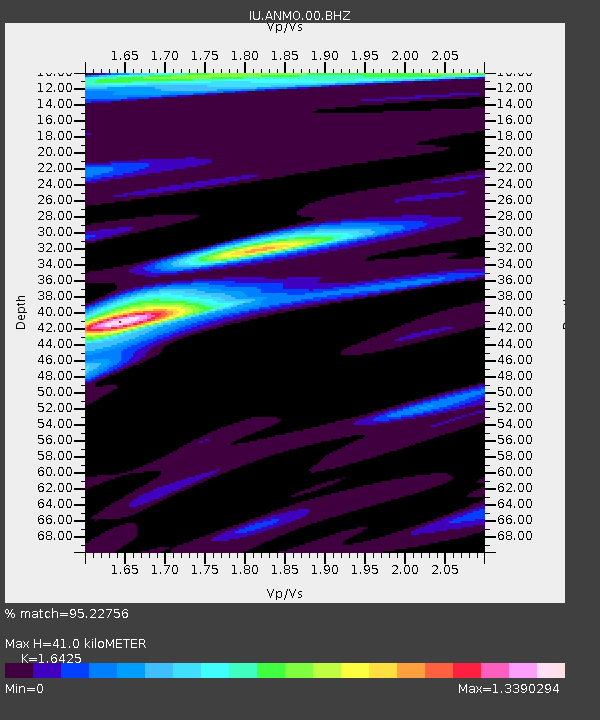
| Estimated Moho Depth: |
41.0 km |
| Estimated Crust Vp/Vs: |
1.64 |
| Assumed Crust Vp: |
6.502 km/s |
| Estimated Crust Vs: |
3.958 km/s |
| Estimated Crust Poisson's Ratio: |
0.21 |
|
| Radial Match: |
95.22756 % |
| Radial Bump: |
370 |
| Transverse Match: |
86.26746 % |
| Transverse Bump: |
400 |
| SOD ConfigId: |
558545 |
| Insert Time: |
2013-09-17 23:27:23.082 +0000 |
| GWidth: |
2.5 |
| Max Bumps: |
400 |
| Tol: |
0.001 |
|

Signal To Noise
| Channel | StoN | STA | LTA |
| IU:ANMO:00:BHZ:20121114T19:12:51.619023Z | 15.764021 | 1.6225418E-6 | 1.02926904E-7 |
| IU:ANMO:00:BH1:20121114T19:12:51.619023Z | 8.934616 | 6.9720176E-7 | 7.803377E-8 |
| IU:ANMO:00:BH2:20121114T19:12:51.619023Z | 1.4230887 | 1.158926E-7 | 8.143736E-8 |
| Arrivals |
| Ps | 4.2 SECOND |
| PpPs | 16 SECOND |
| PsPs/PpSs | 20 SECOND |


