You are here: Home > Network List > IU - Global Seismograph Network (GSN - IRIS/USGS) Stations List
> Station TEIG Tepich, Yucatan, Mexico > Earthquake Result Viewer
TEIG Tepich, Yucatan, Mexico - Earthquake Result Viewer

| Earthquake location: |
Near Coast Of Central Chile |
| Earthquake latitude/longitude: |
-29.1/-71.2 |
| Earthquake time(UTC): |
2012/11/14 (319) 19:02:06 GMT |
| Earthquake Depth: |
63 km |
| Earthquake Magnitude: |
6.1 MW, 6.2 MW, 6.2 MB |
| Earthquake Catalog/Contributor: |
NEIC PDE/NEIC PDE-W |
|
| Network: |
IU Global Seismograph Network (GSN - IRIS/USGS) |
| Station: |
TEIG Tepich, Yucatan, Mexico |
| Lat/Lon: |
20.23 N/88.28 W |
| Elevation: |
40 m |
|
| Distance: |
51.8 deg |
| Az: |
339.432 deg |
| Baz: |
160.892 deg |
| Ray Param: |
0.06702854 |
| Estimated Moho Depth: |
51.5 km |
| Estimated Crust Vp/Vs: |
1.95 |
| Assumed Crust Vp: |
5.817 km/s |
| Estimated Crust Vs: |
2.979 km/s |
| Estimated Crust Poisson's Ratio: |
0.32 |
|
| Radial Match: |
87.44209 % |
| Radial Bump: |
400 |
| Transverse Match: |
87.31108 % |
| Transverse Bump: |
400 |
| SOD ConfigId: |
558545 |
| Insert Time: |
2013-09-17 23:28:25.777 +0000 |
| GWidth: |
2.5 |
| Max Bumps: |
400 |
| Tol: |
0.001 |
|
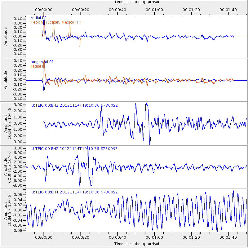
Signal To Noise
| Channel | StoN | STA | LTA |
| IU:TEIG:00:BHZ:20121114T19:10:36.673009Z | 7.8346977 | 2.3828818E-6 | 3.041447E-7 |
| IU:TEIG:00:BH1:20121114T19:10:36.673009Z | 0.8555669 | 3.1029458E-8 | 3.6267714E-8 |
| IU:TEIG:00:BH2:20121114T19:10:36.673009Z | 5.3862424 | 1.267173E-6 | 2.3526106E-7 |
| Arrivals |
| Ps | 8.8 SECOND |
| PpPs | 25 SECOND |
| PsPs/PpSs | 34 SECOND |


