You are here: Home > Network List > IU - Global Seismograph Network (GSN - IRIS/USGS) Stations List
> Station WVT Waverly, Tennessee, USA > Earthquake Result Viewer
WVT Waverly, Tennessee, USA - Earthquake Result Viewer

| Earthquake location: |
Near Coast Of Central Chile |
| Earthquake latitude/longitude: |
-29.1/-71.2 |
| Earthquake time(UTC): |
2012/11/14 (319) 19:02:06 GMT |
| Earthquake Depth: |
63 km |
| Earthquake Magnitude: |
6.1 MW, 6.2 MW, 6.2 MB |
| Earthquake Catalog/Contributor: |
NEIC PDE/NEIC PDE-W |
|
| Network: |
IU Global Seismograph Network (GSN - IRIS/USGS) |
| Station: |
WVT Waverly, Tennessee, USA |
| Lat/Lon: |
36.13 N/87.83 W |
| Elevation: |
170 m |
|
| Distance: |
66.8 deg |
| Az: |
345.387 deg |
| Baz: |
164.176 deg |
| Ray Param: |
0.05725341 |
| Estimated Moho Depth: |
53.25 km |
| Estimated Crust Vp/Vs: |
1.67 |
| Assumed Crust Vp: |
6.444 km/s |
| Estimated Crust Vs: |
3.864 km/s |
| Estimated Crust Poisson's Ratio: |
0.22 |
|
| Radial Match: |
89.050995 % |
| Radial Bump: |
400 |
| Transverse Match: |
68.86929 % |
| Transverse Bump: |
400 |
| SOD ConfigId: |
558545 |
| Insert Time: |
2013-09-17 23:28:39.797 +0000 |
| GWidth: |
2.5 |
| Max Bumps: |
400 |
| Tol: |
0.001 |
|
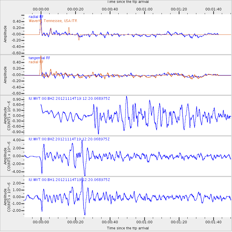
Signal To Noise
| Channel | StoN | STA | LTA |
| IU:WVT:00:BHZ:20121114T19:12:20.068975Z | 7.1228757 | 1.6245874E-6 | 2.2808027E-7 |
| IU:WVT:00:BH1:20121114T19:12:20.068975Z | 3.8938184 | 7.476373E-7 | 1.920062E-7 |
| IU:WVT:00:BH2:20121114T19:12:20.068975Z | 2.3163939 | 4.4925721E-7 | 1.939468E-7 |
| Arrivals |
| Ps | 5.8 SECOND |
| PpPs | 21 SECOND |
| PsPs/PpSs | 27 SECOND |


