You are here: Home > Network List > UW - Pacific Northwest Regional Seismic Network Stations List
> Station YACT Amboy, WA, USA > Earthquake Result Viewer
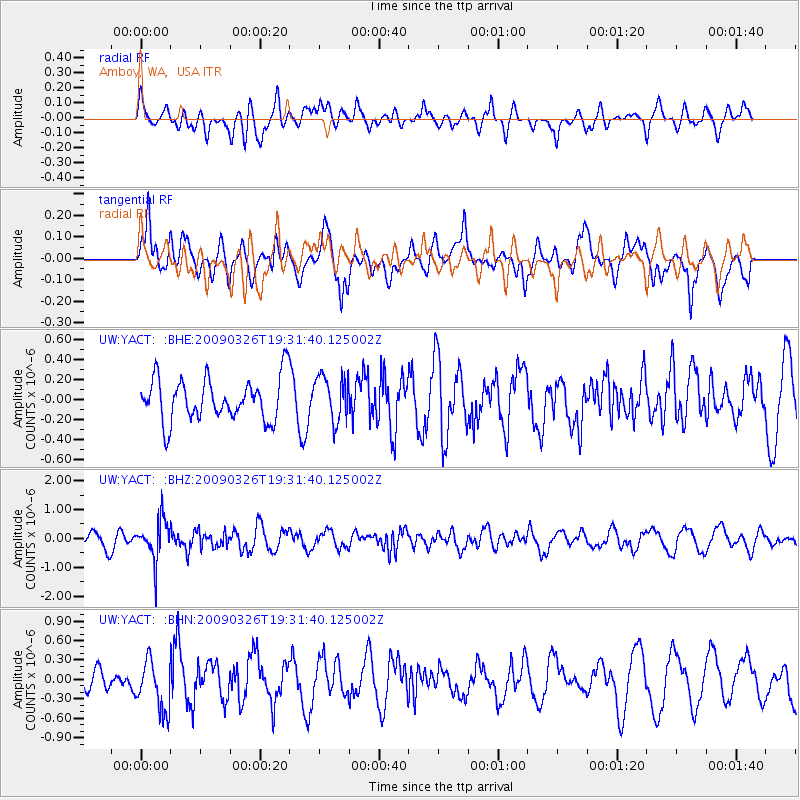
YACT Amboy, WA, USA - Earthquake Result Viewer
*The percent match for this event was below the threshold and hence no stack was calculated.
| Earthquake location: |
Northwest Of Ryukyu Islands |
| Earthquake latitude/longitude: |
27.4/126.7 |
| Earthquake time(UTC): |
2009/03/26 (085) 19:19:59 GMT |
| Earthquake Depth: |
160 km |
| Earthquake Magnitude: |
5.6 MB, 5.9 MW, 5.9 MW |
| Earthquake Catalog/Contributor: |
WHDF/NEIC |
|
| Network: |
UW Pacific Northwest Regional Seismic Network |
| Station: |
YACT Amboy, WA, USA |
| Lat/Lon: |
45.93 N/122.42 W |
| Elevation: |
211 m |
|
| Distance: |
83.9 deg |
| Az: |
40.984 deg |
| Baz: |
303.346 deg |
| Ray Param: |
$rayparam |
*The percent match for this event was below the threshold and hence was not used in the summary stack. |
|
| Radial Match: |
42.199955 % |
| Radial Bump: |
400 |
| Transverse Match: |
56.624508 % |
| Transverse Bump: |
400 |
| SOD ConfigId: |
2658 |
| Insert Time: |
2010-02-27 05:25:06.598 +0000 |
| GWidth: |
2.5 |
| Max Bumps: |
400 |
| Tol: |
0.001 |
|
Signal To Noise
| Channel | StoN | STA | LTA |
| UW:YACT: :BHZ:20090326T19:31:40.125002Z | 2.8055484 | 7.002507E-7 | 2.4959496E-7 |
| UW:YACT: :BHN:20090326T19:31:40.125002Z | 1.3554705 | 3.8696837E-7 | 2.8548635E-7 |
| UW:YACT: :BHE:20090326T19:31:40.125002Z | 1.0623759 | 2.2618983E-7 | 2.1290941E-7 |
| Arrivals |
| Ps | |
| PpPs | |
| PsPs/PpSs | |


