You are here: Home > Network List > US - United States National Seismic Network Stations List
> Station HAWA Hanford, Washington, USA > Earthquake Result Viewer
HAWA Hanford, Washington, USA - Earthquake Result Viewer
*The percent match for this event was below the threshold and hence no stack was calculated.
| Earthquake location: |
Near Coast Of Central Chile |
| Earthquake latitude/longitude: |
-29.1/-71.2 |
| Earthquake time(UTC): |
2012/11/14 (319) 19:02:06 GMT |
| Earthquake Depth: |
63 km |
| Earthquake Magnitude: |
6.1 MW, 6.2 MW, 6.2 MB |
| Earthquake Catalog/Contributor: |
NEIC PDE/NEIC PDE-W |
|
| Network: |
US United States National Seismic Network |
| Station: |
HAWA Hanford, Washington, USA |
| Lat/Lon: |
46.39 N/119.53 W |
| Elevation: |
364 m |
|
| Distance: |
87.0 deg |
| Az: |
328.812 deg |
| Baz: |
139.106 deg |
| Ray Param: |
$rayparam |
*The percent match for this event was below the threshold and hence was not used in the summary stack. |
|
| Radial Match: |
76.206985 % |
| Radial Bump: |
400 |
| Transverse Match: |
68.88181 % |
| Transverse Bump: |
400 |
| SOD ConfigId: |
558545 |
| Insert Time: |
2013-09-17 23:30:16.321 +0000 |
| GWidth: |
2.5 |
| Max Bumps: |
400 |
| Tol: |
0.001 |
|
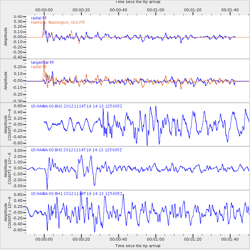
Signal To Noise
| Channel | StoN | STA | LTA |
| US:HAWA:00:BHZ:20121114T19:14:13.125005Z | 13.221674 | 1.2376754E-6 | 9.3609586E-8 |
| US:HAWA:00:BH1:20121114T19:14:13.125005Z | 1.7036833 | 1.9024324E-7 | 1.1166585E-7 |
| US:HAWA:00:BH2:20121114T19:14:13.125005Z | 2.0246665 | 2.2112575E-7 | 1.09215875E-7 |
| Arrivals |
| Ps | |
| PpPs | |
| PsPs/PpSs | |


