You are here: Home > Network List > US - United States National Seismic Network Stations List
> Station TPNV Topopah Spring, Nevada, USA > Earthquake Result Viewer
TPNV Topopah Spring, Nevada, USA - Earthquake Result Viewer

| Earthquake location: |
Near Coast Of Central Chile |
| Earthquake latitude/longitude: |
-29.1/-71.2 |
| Earthquake time(UTC): |
2012/11/14 (319) 19:02:06 GMT |
| Earthquake Depth: |
63 km |
| Earthquake Magnitude: |
6.1 MW, 6.2 MW, 6.2 MB |
| Earthquake Catalog/Contributor: |
NEIC PDE/NEIC PDE-W |
|
| Network: |
US United States National Seismic Network |
| Station: |
TPNV Topopah Spring, Nevada, USA |
| Lat/Lon: |
36.95 N/116.25 W |
| Elevation: |
1600 m |
|
| Distance: |
78.1 deg |
| Az: |
324.591 deg |
| Baz: |
140.739 deg |
| Ray Param: |
0.04971301 |
| Estimated Moho Depth: |
11.25 km |
| Estimated Crust Vp/Vs: |
1.62 |
| Assumed Crust Vp: |
6.279 km/s |
| Estimated Crust Vs: |
3.876 km/s |
| Estimated Crust Poisson's Ratio: |
0.19 |
|
| Radial Match: |
91.901764 % |
| Radial Bump: |
400 |
| Transverse Match: |
91.00372 % |
| Transverse Bump: |
400 |
| SOD ConfigId: |
558545 |
| Insert Time: |
2013-09-17 23:31:38.700 +0000 |
| GWidth: |
2.5 |
| Max Bumps: |
400 |
| Tol: |
0.001 |
|
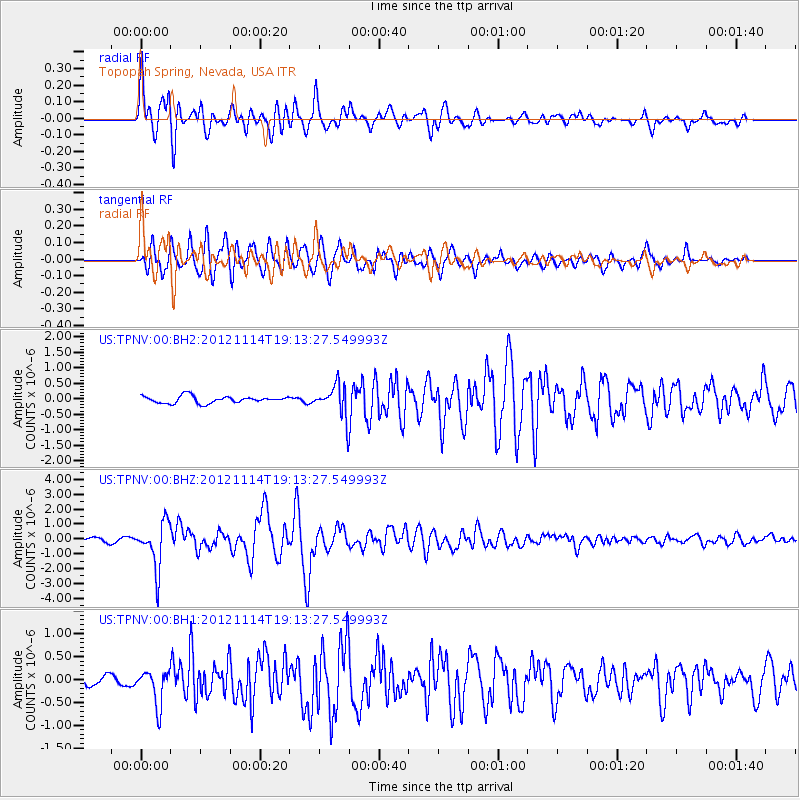
Signal To Noise
| Channel | StoN | STA | LTA |
| US:TPNV:00:BHZ:20121114T19:13:27.549993Z | 14.885353 | 1.540828E-6 | 1.03513024E-7 |
| US:TPNV:00:BH1:20121114T19:13:27.549993Z | 4.0486336 | 3.7585056E-7 | 9.283393E-8 |
| US:TPNV:00:BH2:20121114T19:13:27.549993Z | 4.539358 | 5.0951553E-7 | 1.1224395E-7 |
| Arrivals |
| Ps | 1.1 SECOND |
| PpPs | 4.6 SECOND |
| PsPs/PpSs | 5.7 SECOND |


