You are here: Home > Network List > XJ13 - CRAFTI Stations List
> Station LL23 Sali PS > Earthquake Result Viewer
LL23 Sali PS - Earthquake Result Viewer
| Earthquake location: |
Southern Greece |
| Earthquake latitude/longitude: |
36.7/23.8 |
| Earthquake time(UTC): |
2014/08/29 (241) 03:45:06 GMT |
| Earthquake Depth: |
92 km |
| Earthquake Magnitude: |
5.6 MB |
| Earthquake Catalog/Contributor: |
NEIC PDE/NEIC COMCAT |
|
| Network: |
XJ CRAFTI |
| Station: |
LL23 Sali PS |
| Lat/Lon: |
2.30 S/35.69 E |
| Elevation: |
1257 m |
|
| Distance: |
40.4 deg |
| Az: |
161.409 deg |
| Baz: |
345.149 deg |
| Ray Param: |
0.07412525 |
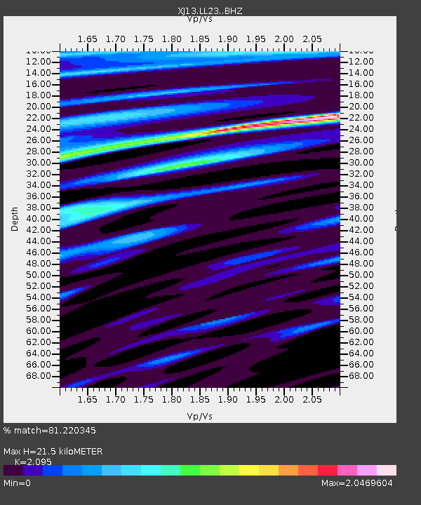
| Estimated Moho Depth: |
21.5 km |
| Estimated Crust Vp/Vs: |
2.10 |
| Assumed Crust Vp: |
6.576 km/s |
| Estimated Crust Vs: |
3.139 km/s |
| Estimated Crust Poisson's Ratio: |
0.35 |
|
| Radial Match: |
81.220345 % |
| Radial Bump: |
400 |
| Transverse Match: |
52.621037 % |
| Transverse Bump: |
400 |
| SOD ConfigId: |
3390531 |
| Insert Time: |
2019-04-13 16:55:27.360 +0000 |
| GWidth: |
2.5 |
| Max Bumps: |
400 |
| Tol: |
0.001 |
|

Signal To Noise
| Channel | StoN | STA | LTA |
| XJ:LL23: :BHZ:20140829T03:52:04.199999Z | 2.563374 | 4.724578E-7 | 1.8431092E-7 |
| XJ:LL23: :BHN:20140829T03:52:04.199999Z | 3.8457096 | 2.635738E-7 | 6.8537105E-8 |
| XJ:LL23: :BHE:20140829T03:52:04.199999Z | 0.49343953 | 1.1650954E-7 | 2.3611716E-7 |
| Arrivals |
| Ps | 3.8 SECOND |
| PpPs | 9.5 SECOND |
| PsPs/PpSs | 13 SECOND |


