You are here: Home > Network List > XJ13 - CRAFTI Stations List
> Station LN14 Matela PS > Earthquake Result Viewer
LN14 Matela PS - Earthquake Result Viewer
| Earthquake location: |
Southern Greece |
| Earthquake latitude/longitude: |
36.7/23.8 |
| Earthquake time(UTC): |
2014/08/29 (241) 03:45:06 GMT |
| Earthquake Depth: |
92 km |
| Earthquake Magnitude: |
5.6 MB |
| Earthquake Catalog/Contributor: |
NEIC PDE/NEIC COMCAT |
|
| Network: |
XJ CRAFTI |
| Station: |
LN14 Matela PS |
| Lat/Lon: |
2.44 S/36.42 E |
| Elevation: |
1631 m |
|
| Distance: |
40.7 deg |
| Az: |
160.391 deg |
| Baz: |
344.346 deg |
| Ray Param: |
0.07392464 |
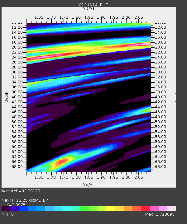
| Estimated Moho Depth: |
18.25 km |
| Estimated Crust Vp/Vs: |
2.10 |
| Assumed Crust Vp: |
6.601 km/s |
| Estimated Crust Vs: |
3.147 km/s |
| Estimated Crust Poisson's Ratio: |
0.35 |
|
| Radial Match: |
83.39173 % |
| Radial Bump: |
353 |
| Transverse Match: |
62.94829 % |
| Transverse Bump: |
397 |
| SOD ConfigId: |
3390531 |
| Insert Time: |
2019-04-13 16:55:31.953 +0000 |
| GWidth: |
2.5 |
| Max Bumps: |
400 |
| Tol: |
0.001 |
|

Signal To Noise
| Channel | StoN | STA | LTA |
| XJ:LN14: :BHZ:20140829T03:52:06.900011Z | 1.8672856 | 4.5245935E-7 | 2.423086E-7 |
| XJ:LN14: :BHN:20140829T03:52:06.900011Z | 1.6058371 | 2.7959524E-7 | 1.7411183E-7 |
| XJ:LN14: :BHE:20140829T03:52:06.900011Z | 1.5116097 | 2.2947926E-7 | 1.518112E-7 |
| Arrivals |
| Ps | 3.2 SECOND |
| PpPs | 8.1 SECOND |
| PsPs/PpSs | 11 SECOND |


