You are here: Home > Network List > IU - Global Seismograph Network (GSN - IRIS/USGS) Stations List
> Station SAML Samuel, Brazil > Earthquake Result Viewer
SAML Samuel, Brazil - Earthquake Result Viewer
| Earthquake location: |
Guerrero, Mexico |
| Earthquake latitude/longitude: |
18.3/-100.4 |
| Earthquake time(UTC): |
2012/11/15 (320) 09:20:21 GMT |
| Earthquake Depth: |
53 km |
| Earthquake Magnitude: |
6.1 MW, 5.7 MB, 6.1 MW |
| Earthquake Catalog/Contributor: |
NEIC PDE/NEIC PDE-W |
|
| Network: |
IU Global Seismograph Network (GSN - IRIS/USGS) |
| Station: |
SAML Samuel, Brazil |
| Lat/Lon: |
8.95 S/63.18 W |
| Elevation: |
120 m |
|
| Distance: |
45.6 deg |
| Az: |
123.342 deg |
| Baz: |
306.571 deg |
| Ray Param: |
0.070996344 |
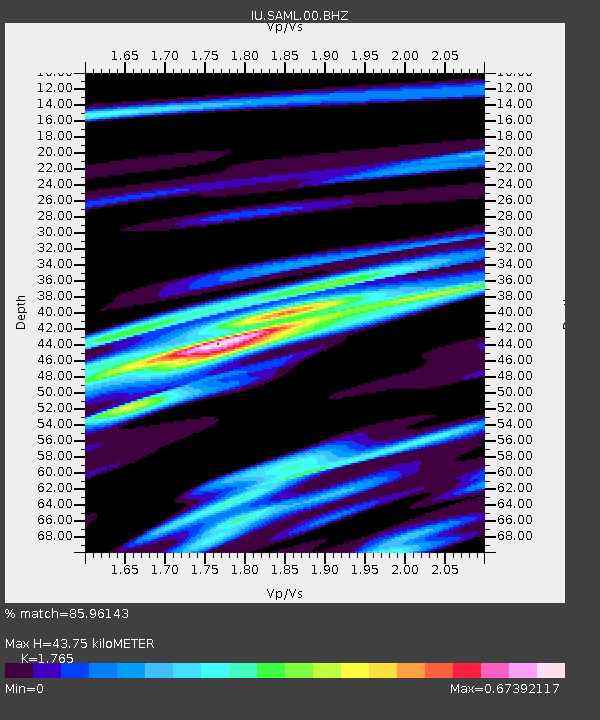
| Estimated Moho Depth: |
43.75 km |
| Estimated Crust Vp/Vs: |
1.76 |
| Assumed Crust Vp: |
6.498 km/s |
| Estimated Crust Vs: |
3.681 km/s |
| Estimated Crust Poisson's Ratio: |
0.26 |
|
| Radial Match: |
85.96143 % |
| Radial Bump: |
299 |
| Transverse Match: |
69.46899 % |
| Transverse Bump: |
400 |
| SOD ConfigId: |
558545 |
| Insert Time: |
2013-09-17 23:38:06.238 +0000 |
| GWidth: |
2.5 |
| Max Bumps: |
400 |
| Tol: |
0.001 |
|

Signal To Noise
| Channel | StoN | STA | LTA |
| IU:SAML:00:BHZ:20121115T09:28:06.71899Z | 12.937568 | 1.4073856E-6 | 1.0878286E-7 |
| IU:SAML:00:BH1:20121115T09:28:06.71899Z | 8.560282 | 7.6885516E-7 | 8.9816574E-8 |
| IU:SAML:00:BH2:20121115T09:28:06.71899Z | 3.841072 | 3.9489188E-7 | 1.0280772E-7 |
| Arrivals |
| Ps | 5.5 SECOND |
| PpPs | 17 SECOND |
| PsPs/PpSs | 23 SECOND |


