You are here: Home > Network List > US - United States National Seismic Network Stations List
> Station EGMT Eagleton, Montana, USA > Earthquake Result Viewer
EGMT Eagleton, Montana, USA - Earthquake Result Viewer
| Earthquake location: |
Guerrero, Mexico |
| Earthquake latitude/longitude: |
18.3/-100.4 |
| Earthquake time(UTC): |
2012/11/15 (320) 09:20:21 GMT |
| Earthquake Depth: |
53 km |
| Earthquake Magnitude: |
6.1 MW, 5.7 MB, 6.1 MW |
| Earthquake Catalog/Contributor: |
NEIC PDE/NEIC PDE-W |
|
| Network: |
US United States National Seismic Network |
| Station: |
EGMT Eagleton, Montana, USA |
| Lat/Lon: |
48.02 N/109.75 W |
| Elevation: |
1055 m |
|
| Distance: |
30.6 deg |
| Az: |
347.589 deg |
| Baz: |
162.296 deg |
| Ray Param: |
0.0792267 |
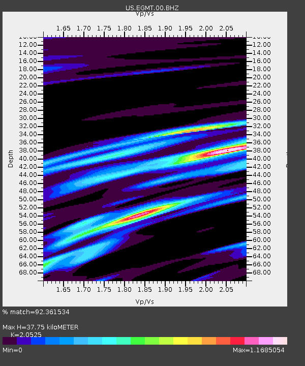
| Estimated Moho Depth: |
37.75 km |
| Estimated Crust Vp/Vs: |
2.05 |
| Assumed Crust Vp: |
6.438 km/s |
| Estimated Crust Vs: |
3.136 km/s |
| Estimated Crust Poisson's Ratio: |
0.34 |
|
| Radial Match: |
92.361534 % |
| Radial Bump: |
279 |
| Transverse Match: |
55.33019 % |
| Transverse Bump: |
400 |
| SOD ConfigId: |
558545 |
| Insert Time: |
2013-09-17 23:38:45.489 +0000 |
| GWidth: |
2.5 |
| Max Bumps: |
400 |
| Tol: |
0.001 |
|
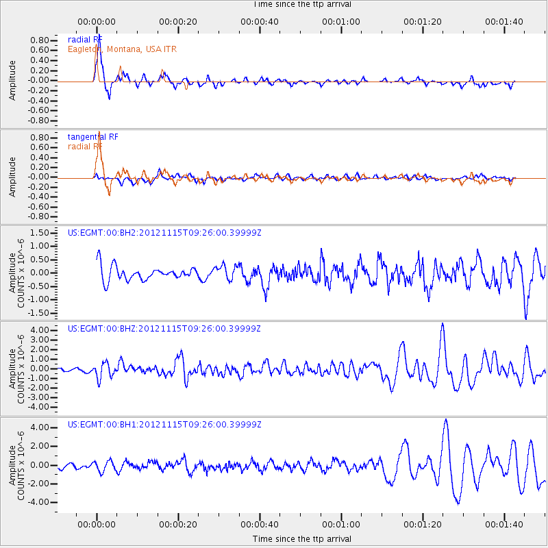
Signal To Noise
| Channel | StoN | STA | LTA |
| US:EGMT:00:BHZ:20121115T09:26:00.39999Z | 5.763983 | 7.887533E-7 | 1.3684172E-7 |
| US:EGMT:00:BH1:20121115T09:26:00.39999Z | 2.3876693 | 5.578021E-7 | 2.336178E-7 |
| US:EGMT:00:BH2:20121115T09:26:00.39999Z | 1.0049157 | 2.6458082E-7 | 2.6328658E-7 |
| Arrivals |
| Ps | 6.6 SECOND |
| PpPs | 17 SECOND |
| PsPs/PpSs | 23 SECOND |


