You are here: Home > Network List > II - Global Seismograph Network (GSN - IRIS/IDA) Stations List
> Station WRAB Tennant Creek, NT, Australia > Earthquake Result Viewer
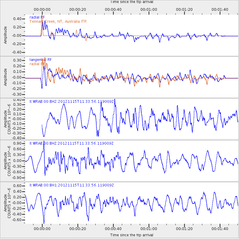
WRAB Tennant Creek, NT, Australia - Earthquake Result Viewer
*The percent match for this event was below the threshold and hence no stack was calculated.
| Earthquake location: |
Near Islands, Aleutian Islands |
| Earthquake latitude/longitude: |
52.5/173.4 |
| Earthquake time(UTC): |
2012/11/15 (320) 11:22:22 GMT |
| Earthquake Depth: |
28 km |
| Earthquake Magnitude: |
5.6 MW, 5.5 MW, 5.6 MB |
| Earthquake Catalog/Contributor: |
NEIC PDE/NEIC PDE-W |
|
| Network: |
II Global Seismograph Network (GSN - IRIS/IDA) |
| Station: |
WRAB Tennant Creek, NT, Australia |
| Lat/Lon: |
19.93 S/134.36 E |
| Elevation: |
366 m |
|
| Distance: |
79.7 deg |
| Az: |
216.989 deg |
| Baz: |
23.016 deg |
| Ray Param: |
$rayparam |
*The percent match for this event was below the threshold and hence was not used in the summary stack. |
|
| Radial Match: |
67.29887 % |
| Radial Bump: |
400 |
| Transverse Match: |
53.813362 % |
| Transverse Bump: |
400 |
| SOD ConfigId: |
558545 |
| Insert Time: |
2013-09-17 23:40:25.107 +0000 |
| GWidth: |
2.5 |
| Max Bumps: |
400 |
| Tol: |
0.001 |
|
Signal To Noise
| Channel | StoN | STA | LTA |
| II:WRAB:00:BHZ:20121115T11:33:56.119009Z | 2.0017948 | 4.3217577E-7 | 2.1589413E-7 |
| II:WRAB:00:BH1:20121115T11:33:56.119009Z | 1.4540814 | 2.599508E-7 | 1.7877322E-7 |
| II:WRAB:00:BH2:20121115T11:33:56.119009Z | 1.3731278 | 2.1320628E-7 | 1.5527051E-7 |
| Arrivals |
| Ps | |
| PpPs | |
| PsPs/PpSs | |


