You are here: Home > Network List > US - United States National Seismic Network Stations List
> Station MSO Missoula, Montana, USA > Earthquake Result Viewer
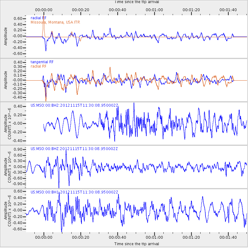
MSO Missoula, Montana, USA - Earthquake Result Viewer
*The percent match for this event was below the threshold and hence no stack was calculated.
| Earthquake location: |
Near Islands, Aleutian Islands |
| Earthquake latitude/longitude: |
52.5/173.4 |
| Earthquake time(UTC): |
2012/11/15 (320) 11:22:22 GMT |
| Earthquake Depth: |
28 km |
| Earthquake Magnitude: |
5.6 MW, 5.5 MW, 5.6 MB |
| Earthquake Catalog/Contributor: |
NEIC PDE/NEIC PDE-W |
|
| Network: |
US United States National Seismic Network |
| Station: |
MSO Missoula, Montana, USA |
| Lat/Lon: |
46.83 N/113.94 W |
| Elevation: |
1264 m |
|
| Distance: |
45.6 deg |
| Az: |
66.652 deg |
| Baz: |
305.162 deg |
| Ray Param: |
$rayparam |
*The percent match for this event was below the threshold and hence was not used in the summary stack. |
|
| Radial Match: |
68.08939 % |
| Radial Bump: |
400 |
| Transverse Match: |
69.27224 % |
| Transverse Bump: |
400 |
| SOD ConfigId: |
558545 |
| Insert Time: |
2013-09-17 23:43:21.062 +0000 |
| GWidth: |
2.5 |
| Max Bumps: |
400 |
| Tol: |
0.001 |
|
Signal To Noise
| Channel | StoN | STA | LTA |
| US:MSO:00:BHZ:20121115T11:30:08.950002Z | 2.2956583 | 3.1381757E-7 | 1.3670046E-7 |
| US:MSO:00:BH1:20121115T11:30:08.950002Z | 1.9968939 | 1.76332E-7 | 8.830313E-8 |
| US:MSO:00:BH2:20121115T11:30:08.950002Z | 1.0639036 | 1.4104796E-7 | 1.325759E-7 |
| Arrivals |
| Ps | |
| PpPs | |
| PsPs/PpSs | |


