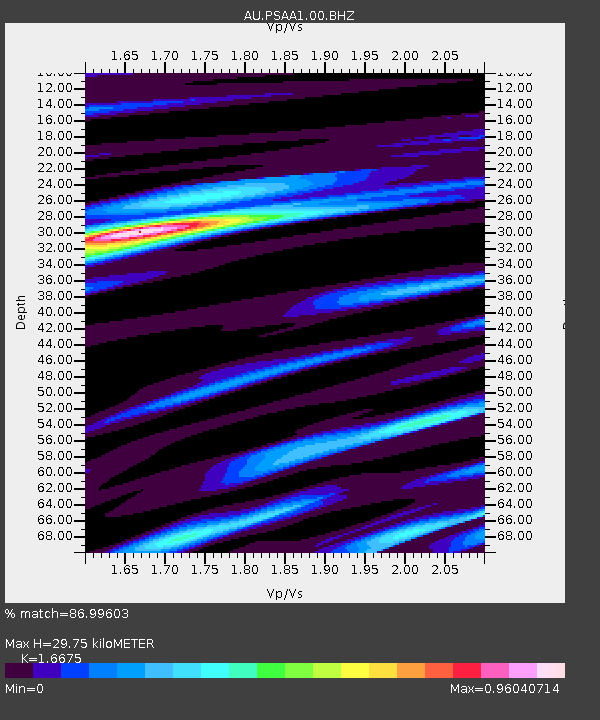
PSAA1 Pilbara Seismic Array Element A1 - Earthquake Result Viewer

Earthquake location: Kuril Islands
Earthquake latitude/longitude: 49.3/155.4
Earthquake time(UTC): 2012/11/16 (321) 18:12:39 GMT
Earthquake Depth: 29 km
Earthquake Magnitude: 6.5 MW, 6.1 MB, 6.3 MS, 6.5 MW
Earthquake Catalog/Contributor: NEIC PDE/NEIC PDE-W
Network: AU Australian Seismological Centre
Station: PSAA1 Pilbara Seismic Array Element A1
Lat/Lon: 21.58 S/119.84 E
Elevation: 325 m
Distance: 77.3 deg
Az: 213.724 deg
Baz: 22.994 deg
Ray Param: 0.05035974
Estimated Moho Depth: 29.75 km
Estimated Crust Vp/Vs: 1.67
Assumed Crust Vp: 6.464 km/s
Estimated Crust Vs: 3.876 km/s
Estimated Crust Poisson's Ratio: 0.22
Radial Match: 86.99603 %
Radial Bump: 400
Transverse Match: 75.86873 %
Transverse Bump: 400
SOD ConfigId: 558545
Insert Time: 2013-09-17 23:47:10.013 +0000
GWidth: 2.5
Max Bumps: 400
Tol: 0.001

Signal To Noise

ChannelStoNSTALTA
AU:PSAA1:00:BHZ:20121116T18:24:00.618984Z13.5200762.8073725E-62.0764473E-7
AU:PSAA1:00:BH1:20121116T18:24:00.618984Z5.95415839.628644E-71.6171293E-7
AU:PSAA1:00:BH2:20121116T18:24:00.618984Z3.85164286.2679754E-71.627351E-7
Arrivals
Ps3.2 SECOND
PpPs12 SECOND
PsPs/PpSs15 SECOND