You are here: Home > Network List > II - Global Seismograph Network (GSN - IRIS/IDA) Stations List
> Station NIL Nilore, Pakistan > Earthquake Result Viewer
NIL Nilore, Pakistan - Earthquake Result Viewer
| Earthquake location: |
Kuril Islands |
| Earthquake latitude/longitude: |
49.3/155.4 |
| Earthquake time(UTC): |
2012/11/16 (321) 18:12:39 GMT |
| Earthquake Depth: |
29 km |
| Earthquake Magnitude: |
6.5 MW, 6.1 MB, 6.3 MS, 6.5 MW |
| Earthquake Catalog/Contributor: |
NEIC PDE/NEIC PDE-W |
|
| Network: |
II Global Seismograph Network (GSN - IRIS/IDA) |
| Station: |
NIL Nilore, Pakistan |
| Lat/Lon: |
33.65 N/73.27 E |
| Elevation: |
629 m |
|
| Distance: |
60.6 deg |
| Az: |
288.418 deg |
| Baz: |
48.149 deg |
| Ray Param: |
0.061399456 |
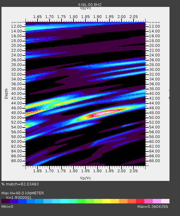
| Estimated Moho Depth: |
48.0 km |
| Estimated Crust Vp/Vs: |
1.93 |
| Assumed Crust Vp: |
6.242 km/s |
| Estimated Crust Vs: |
3.234 km/s |
| Estimated Crust Poisson's Ratio: |
0.32 |
|
| Radial Match: |
92.03463 % |
| Radial Bump: |
400 |
| Transverse Match: |
82.65018 % |
| Transverse Bump: |
400 |
| SOD ConfigId: |
558545 |
| Insert Time: |
2013-09-17 23:48:17.526 +0000 |
| GWidth: |
2.5 |
| Max Bumps: |
400 |
| Tol: |
0.001 |
|

Signal To Noise
| Channel | StoN | STA | LTA |
| II:NIL:00:BHZ:20121116T18:22:16.818997Z | 29.861149 | 5.8263786E-6 | 1.9511567E-7 |
| II:NIL:00:BH1:20121116T18:22:16.818997Z | 11.576379 | 8.2062354E-7 | 7.088776E-8 |
| II:NIL:00:BH2:20121116T18:22:16.818997Z | 10.215085 | 8.4023503E-7 | 8.225433E-8 |
| Arrivals |
| Ps | 7.4 SECOND |
| PpPs | 22 SECOND |
| PsPs/PpSs | 29 SECOND |


