You are here: Home > Network List > IU - Global Seismograph Network (GSN - IRIS/USGS) Stations List
> Station COLA College Outpost, Alaska, USA > Earthquake Result Viewer
COLA College Outpost, Alaska, USA - Earthquake Result Viewer
| Earthquake location: |
Kuril Islands |
| Earthquake latitude/longitude: |
49.3/155.4 |
| Earthquake time(UTC): |
2012/11/16 (321) 18:12:39 GMT |
| Earthquake Depth: |
29 km |
| Earthquake Magnitude: |
6.5 MW, 6.1 MB, 6.3 MS, 6.5 MW |
| Earthquake Catalog/Contributor: |
NEIC PDE/NEIC PDE-W |
|
| Network: |
IU Global Seismograph Network (GSN - IRIS/USGS) |
| Station: |
COLA College Outpost, Alaska, USA |
| Lat/Lon: |
64.87 N/147.86 W |
| Elevation: |
200 m |
|
| Distance: |
33.2 deg |
| Az: |
40.69 deg |
| Baz: |
269.755 deg |
| Ray Param: |
0.078277566 |
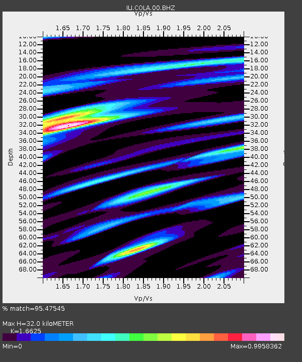
| Estimated Moho Depth: |
32.0 km |
| Estimated Crust Vp/Vs: |
1.66 |
| Assumed Crust Vp: |
6.566 km/s |
| Estimated Crust Vs: |
3.95 km/s |
| Estimated Crust Poisson's Ratio: |
0.22 |
|
| Radial Match: |
95.47545 % |
| Radial Bump: |
360 |
| Transverse Match: |
76.84048 % |
| Transverse Bump: |
400 |
| SOD ConfigId: |
558545 |
| Insert Time: |
2013-09-17 23:48:44.073 +0000 |
| GWidth: |
2.5 |
| Max Bumps: |
400 |
| Tol: |
0.001 |
|

Signal To Noise
| Channel | StoN | STA | LTA |
| IU:COLA:00:BHZ:20121116T18:18:43.619015Z | 23.255224 | 6.0470543E-6 | 2.600299E-7 |
| IU:COLA:00:BH1:20121116T18:18:43.619015Z | 10.628197 | 3.473355E-6 | 3.2680566E-7 |
| IU:COLA:00:BH2:20121116T18:18:43.619015Z | 8.5710125 | 2.8360462E-6 | 3.308881E-7 |
| Arrivals |
| Ps | 3.5 SECOND |
| PpPs | 12 SECOND |
| PsPs/PpSs | 15 SECOND |


