You are here: Home > Network List > IU - Global Seismograph Network (GSN - IRIS/USGS) Stations List
> Station KONO Kongsberg, Norway > Earthquake Result Viewer
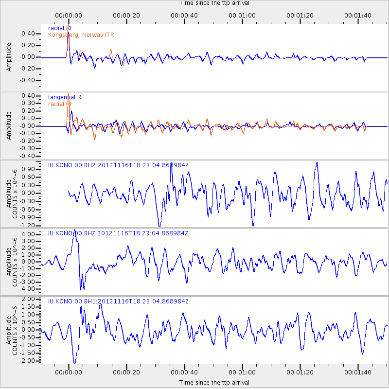
KONO Kongsberg, Norway - Earthquake Result Viewer
*The percent match for this event was below the threshold and hence no stack was calculated.
| Earthquake location: |
Kuril Islands |
| Earthquake latitude/longitude: |
49.3/155.4 |
| Earthquake time(UTC): |
2012/11/16 (321) 18:12:39 GMT |
| Earthquake Depth: |
29 km |
| Earthquake Magnitude: |
6.5 MW, 6.1 MB, 6.3 MS, 6.5 MW |
| Earthquake Catalog/Contributor: |
NEIC PDE/NEIC PDE-W |
|
| Network: |
IU Global Seismograph Network (GSN - IRIS/USGS) |
| Station: |
KONO Kongsberg, Norway |
| Lat/Lon: |
59.65 N/9.60 E |
| Elevation: |
216 m |
|
| Distance: |
67.9 deg |
| Az: |
342.072 deg |
| Baz: |
23.388 deg |
| Ray Param: |
$rayparam |
*The percent match for this event was below the threshold and hence was not used in the summary stack. |
|
| Radial Match: |
54.367115 % |
| Radial Bump: |
400 |
| Transverse Match: |
56.55886 % |
| Transverse Bump: |
400 |
| SOD ConfigId: |
558545 |
| Insert Time: |
2013-09-17 23:49:17.196 +0000 |
| GWidth: |
2.5 |
| Max Bumps: |
400 |
| Tol: |
0.001 |
|
Signal To Noise
| Channel | StoN | STA | LTA |
| IU:KONO:00:BHZ:20121116T18:23:04.868984Z | 5.211232 | 2.7476606E-6 | 5.272574E-7 |
| IU:KONO:00:BH1:20121116T18:23:04.868984Z | 3.0922635 | 1.1829324E-6 | 3.8254578E-7 |
| IU:KONO:00:BH2:20121116T18:23:04.868984Z | 2.9493883 | 6.141344E-7 | 2.0822434E-7 |
| Arrivals |
| Ps | |
| PpPs | |
| PsPs/PpSs | |


