You are here: Home > Network List > IU - Global Seismograph Network (GSN - IRIS/USGS) Stations List
> Station MBWA Marble Bar, Western Australia > Earthquake Result Viewer
MBWA Marble Bar, Western Australia - Earthquake Result Viewer
| Earthquake location: |
Kuril Islands |
| Earthquake latitude/longitude: |
49.3/155.4 |
| Earthquake time(UTC): |
2012/11/16 (321) 18:12:39 GMT |
| Earthquake Depth: |
29 km |
| Earthquake Magnitude: |
6.5 MW, 6.1 MB, 6.3 MS, 6.5 MW |
| Earthquake Catalog/Contributor: |
NEIC PDE/NEIC PDE-W |
|
| Network: |
IU Global Seismograph Network (GSN - IRIS/USGS) |
| Station: |
MBWA Marble Bar, Western Australia |
| Lat/Lon: |
21.16 S/119.73 E |
| Elevation: |
190 m |
|
| Distance: |
77.0 deg |
| Az: |
213.983 deg |
| Baz: |
23.089 deg |
| Ray Param: |
0.05059064 |
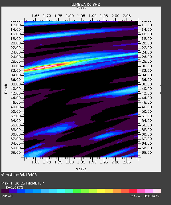
| Estimated Moho Depth: |
30.25 km |
| Estimated Crust Vp/Vs: |
1.69 |
| Assumed Crust Vp: |
6.464 km/s |
| Estimated Crust Vs: |
3.83 km/s |
| Estimated Crust Poisson's Ratio: |
0.23 |
|
| Radial Match: |
86.18493 % |
| Radial Bump: |
400 |
| Transverse Match: |
72.09655 % |
| Transverse Bump: |
400 |
| SOD ConfigId: |
558545 |
| Insert Time: |
2013-09-17 23:49:18.104 +0000 |
| GWidth: |
2.5 |
| Max Bumps: |
400 |
| Tol: |
0.001 |
|

Signal To Noise
| Channel | StoN | STA | LTA |
| IU:MBWA:00:BHZ:20121116T18:23:58.719021Z | 11.194862 | 2.4539595E-6 | 2.1920407E-7 |
| IU:MBWA:00:BH1:20121116T18:23:58.719021Z | 3.0561287 | 5.7225776E-7 | 1.8724923E-7 |
| IU:MBWA:00:BH2:20121116T18:23:58.719021Z | 5.43892 | 9.0858794E-7 | 1.67053E-7 |
| Arrivals |
| Ps | 3.3 SECOND |
| PpPs | 12 SECOND |
| PsPs/PpSs | 15 SECOND |


