You are here: Home > Network List > US - United States National Seismic Network Stations List
> Station CNNC Cliffs of the Neuse, North Carolina, USA > Earthquake Result Viewer
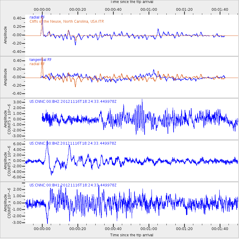
CNNC Cliffs of the Neuse, North Carolina, USA - Earthquake Result Viewer

| Earthquake location: |
Kuril Islands |
| Earthquake latitude/longitude: |
49.3/155.4 |
| Earthquake time(UTC): |
2012/11/16 (321) 18:12:39 GMT |
| Earthquake Depth: |
29 km |
| Earthquake Magnitude: |
6.5 MW, 6.1 MB, 6.3 MS, 6.5 MW |
| Earthquake Catalog/Contributor: |
NEIC PDE/NEIC PDE-W |
|
| Network: |
US United States National Seismic Network |
| Station: |
CNNC Cliffs of the Neuse, North Carolina, USA |
| Lat/Lon: |
35.24 N/77.88 W |
| Elevation: |
17 m |
|
| Distance: |
83.5 deg |
| Az: |
41.348 deg |
| Baz: |
328.094 deg |
| Ray Param: |
0.04613185 |
| Estimated Moho Depth: |
38.0 km |
| Estimated Crust Vp/Vs: |
1.65 |
| Assumed Crust Vp: |
6.565 km/s |
| Estimated Crust Vs: |
3.966 km/s |
| Estimated Crust Poisson's Ratio: |
0.21 |
|
| Radial Match: |
84.92363 % |
| Radial Bump: |
400 |
| Transverse Match: |
61.347954 % |
| Transverse Bump: |
400 |
| SOD ConfigId: |
558545 |
| Insert Time: |
2013-09-17 23:50:51.007 +0000 |
| GWidth: |
2.5 |
| Max Bumps: |
400 |
| Tol: |
0.001 |
|
Signal To Noise
| Channel | StoN | STA | LTA |
| US:CNNC:00:BHZ:20121116T18:24:33.449978Z | 6.9347477 | 3.0366793E-6 | 4.3789325E-7 |
| US:CNNC:00:BH1:20121116T18:24:33.449978Z | 2.4472713 | 1.1568275E-6 | 4.7270095E-7 |
| US:CNNC:00:BH2:20121116T18:24:33.449978Z | 1.415774 | 6.782472E-7 | 4.790646E-7 |
| Arrivals |
| Ps | 3.9 SECOND |
| PpPs | 15 SECOND |
| PsPs/PpSs | 19 SECOND |


