You are here: Home > Network List > US - United States National Seismic Network Stations List
> Station DGMT Dagmar, Montana, USA > Earthquake Result Viewer
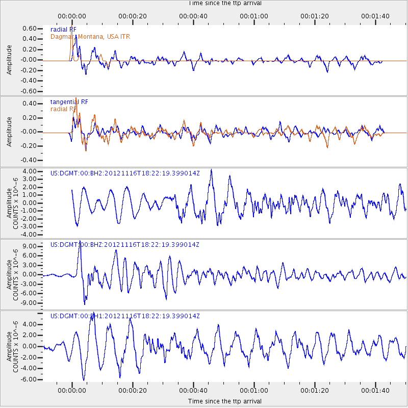
DGMT Dagmar, Montana, USA - Earthquake Result Viewer
*The percent match for this event was below the threshold and hence no stack was calculated.
| Earthquake location: |
Kuril Islands |
| Earthquake latitude/longitude: |
49.3/155.4 |
| Earthquake time(UTC): |
2012/11/16 (321) 18:12:39 GMT |
| Earthquake Depth: |
29 km |
| Earthquake Magnitude: |
6.5 MW, 6.1 MB, 6.3 MS, 6.5 MW |
| Earthquake Catalog/Contributor: |
NEIC PDE/NEIC PDE-W |
|
| Network: |
US United States National Seismic Network |
| Station: |
DGMT Dagmar, Montana, USA |
| Lat/Lon: |
48.47 N/104.20 W |
| Elevation: |
0.0 m |
|
| Distance: |
61.0 deg |
| Az: |
48.487 deg |
| Baz: |
312.536 deg |
| Ray Param: |
$rayparam |
*The percent match for this event was below the threshold and hence was not used in the summary stack. |
|
| Radial Match: |
85.393906 % |
| Radial Bump: |
400 |
| Transverse Match: |
61.36707 % |
| Transverse Bump: |
400 |
| SOD ConfigId: |
558545 |
| Insert Time: |
2013-09-17 23:51:00.018 +0000 |
| GWidth: |
2.5 |
| Max Bumps: |
400 |
| Tol: |
0.001 |
|
Signal To Noise
| Channel | StoN | STA | LTA |
| US:DGMT:00:BHZ:20121116T18:22:19.399014Z | 21.430122 | 5.060269E-6 | 2.3612878E-7 |
| US:DGMT:00:BH1:20121116T18:22:19.399014Z | 2.8369079 | 2.8801985E-6 | 1.0152597E-6 |
| US:DGMT:00:BH2:20121116T18:22:19.399014Z | 0.51687795 | 6.742822E-7 | 1.3045288E-6 |
| Arrivals |
| Ps | |
| PpPs | |
| PsPs/PpSs | |


