You are here: Home > Network List > US - United States National Seismic Network Stations List
> Station ERPA Erie, Pennsylvania, USA > Earthquake Result Viewer
ERPA Erie, Pennsylvania, USA - Earthquake Result Viewer
| Earthquake location: |
Kuril Islands |
| Earthquake latitude/longitude: |
49.3/155.4 |
| Earthquake time(UTC): |
2012/11/16 (321) 18:12:39 GMT |
| Earthquake Depth: |
29 km |
| Earthquake Magnitude: |
6.5 MW, 6.1 MB, 6.3 MS, 6.5 MW |
| Earthquake Catalog/Contributor: |
NEIC PDE/NEIC PDE-W |
|
| Network: |
US United States National Seismic Network |
| Station: |
ERPA Erie, Pennsylvania, USA |
| Lat/Lon: |
42.12 N/79.99 W |
| Elevation: |
306 m |
|
| Distance: |
76.8 deg |
| Az: |
38.988 deg |
| Baz: |
326.373 deg |
| Ray Param: |
0.050714675 |
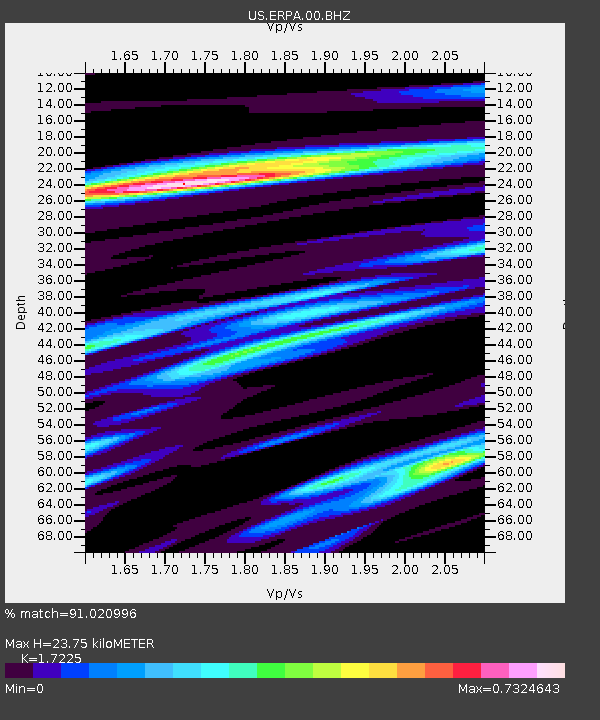
| Estimated Moho Depth: |
23.75 km |
| Estimated Crust Vp/Vs: |
1.72 |
| Assumed Crust Vp: |
6.419 km/s |
| Estimated Crust Vs: |
3.727 km/s |
| Estimated Crust Poisson's Ratio: |
0.25 |
|
| Radial Match: |
91.020996 % |
| Radial Bump: |
340 |
| Transverse Match: |
70.260056 % |
| Transverse Bump: |
400 |
| SOD ConfigId: |
558545 |
| Insert Time: |
2013-09-17 23:51:17.096 +0000 |
| GWidth: |
2.5 |
| Max Bumps: |
400 |
| Tol: |
0.001 |
|
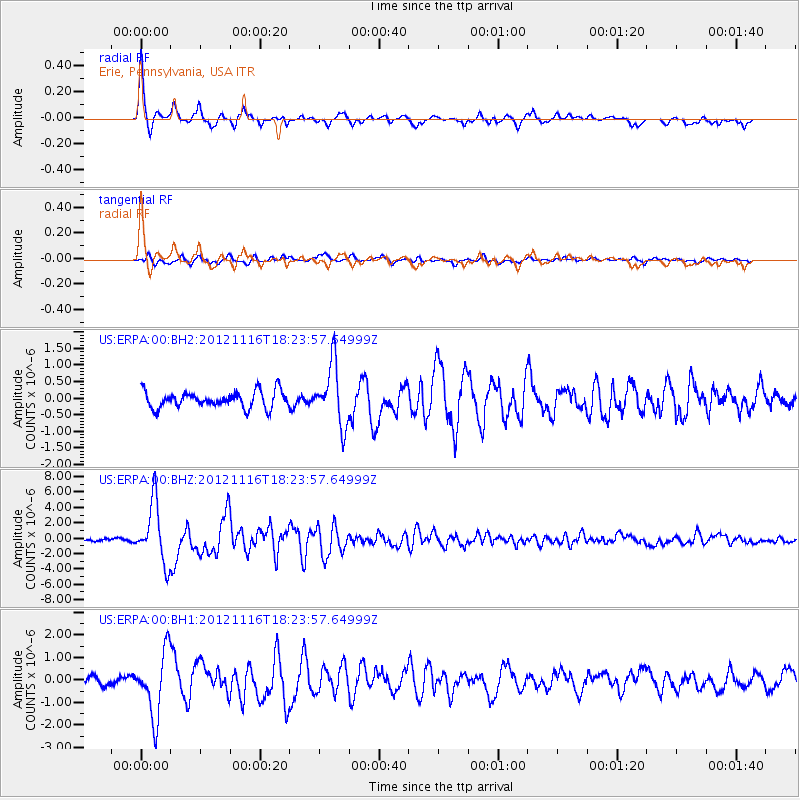
Signal To Noise
| Channel | StoN | STA | LTA |
| US:ERPA:00:BHZ:20121116T18:23:57.64999Z | 20.75557 | 3.863582E-6 | 1.8614676E-7 |
| US:ERPA:00:BH1:20121116T18:23:57.64999Z | 6.5601645 | 1.4299555E-6 | 2.1797557E-7 |
| US:ERPA:00:BH2:20121116T18:23:57.64999Z | 3.6731281 | 9.139839E-7 | 2.4882985E-7 |
| Arrivals |
| Ps | 2.8 SECOND |
| PpPs | 9.8 SECOND |
| PsPs/PpSs | 13 SECOND |


