You are here: Home > Network List > US - United States National Seismic Network Stations List
> Station GOGA Godfrey, Georgia, USA > Earthquake Result Viewer
GOGA Godfrey, Georgia, USA - Earthquake Result Viewer
| Earthquake location: |
Kuril Islands |
| Earthquake latitude/longitude: |
49.3/155.4 |
| Earthquake time(UTC): |
2012/11/16 (321) 18:12:39 GMT |
| Earthquake Depth: |
29 km |
| Earthquake Magnitude: |
6.5 MW, 6.1 MB, 6.3 MS, 6.5 MW |
| Earthquake Catalog/Contributor: |
NEIC PDE/NEIC PDE-W |
|
| Network: |
US United States National Seismic Network |
| Station: |
GOGA Godfrey, Georgia, USA |
| Lat/Lon: |
33.41 N/83.47 W |
| Elevation: |
150 m |
|
| Distance: |
82.5 deg |
| Az: |
46.252 deg |
| Baz: |
325.557 deg |
| Ray Param: |
0.046835035 |
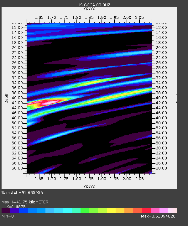
| Estimated Moho Depth: |
41.75 km |
| Estimated Crust Vp/Vs: |
1.69 |
| Assumed Crust Vp: |
6.565 km/s |
| Estimated Crust Vs: |
3.89 km/s |
| Estimated Crust Poisson's Ratio: |
0.23 |
|
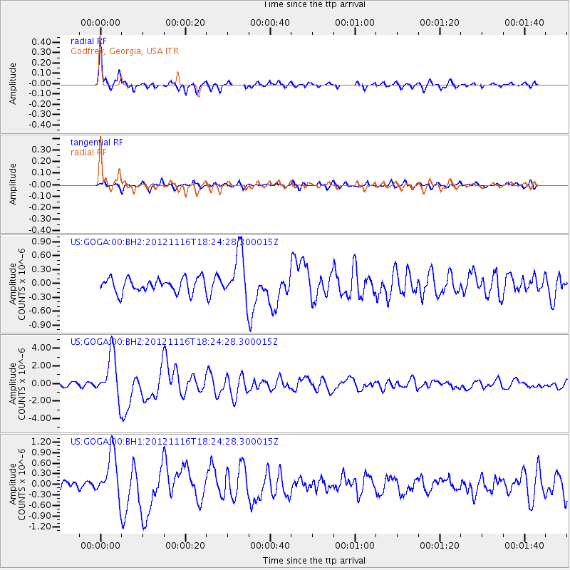
| Radial Match: |
91.665955 % |
| Radial Bump: |
304 |
| Transverse Match: |
78.961624 % |
| Transverse Bump: |
394 |
| SOD ConfigId: |
558545 |
| Insert Time: |
2013-09-17 23:51:25.493 +0000 |
| GWidth: |
2.5 |
| Max Bumps: |
400 |
| Tol: |
0.001 |
|
Signal To Noise
| Channel | StoN | STA | LTA |
| US:GOGA:00:BHZ:20121116T18:24:28.300015Z | 11.5869875 | 2.6282366E-6 | 2.2682657E-7 |
| US:GOGA:00:BH1:20121116T18:24:28.300015Z | 4.010689 | 6.765751E-7 | 1.68693E-7 |
| US:GOGA:00:BH2:20121116T18:24:28.300015Z | 3.5748649 | 5.418747E-7 | 1.5157909E-7 |
| Arrivals |
| Ps | 4.5 SECOND |
| PpPs | 17 SECOND |
| PsPs/PpSs | 21 SECOND |


