You are here: Home > Network List > US - United States National Seismic Network Stations List
> Station HDIL Hopedale, Illinois, USA > Earthquake Result Viewer
HDIL Hopedale, Illinois, USA - Earthquake Result Viewer
| Earthquake location: |
Kuril Islands |
| Earthquake latitude/longitude: |
49.3/155.4 |
| Earthquake time(UTC): |
2012/11/16 (321) 18:12:39 GMT |
| Earthquake Depth: |
29 km |
| Earthquake Magnitude: |
6.5 MW, 6.1 MB, 6.3 MS, 6.5 MW |
| Earthquake Catalog/Contributor: |
NEIC PDE/NEIC PDE-W |
|
| Network: |
US United States National Seismic Network |
| Station: |
HDIL Hopedale, Illinois, USA |
| Lat/Lon: |
40.56 N/89.29 W |
| Elevation: |
219 m |
|
| Distance: |
74.0 deg |
| Az: |
45.797 deg |
| Baz: |
321.964 deg |
| Ray Param: |
0.052618194 |
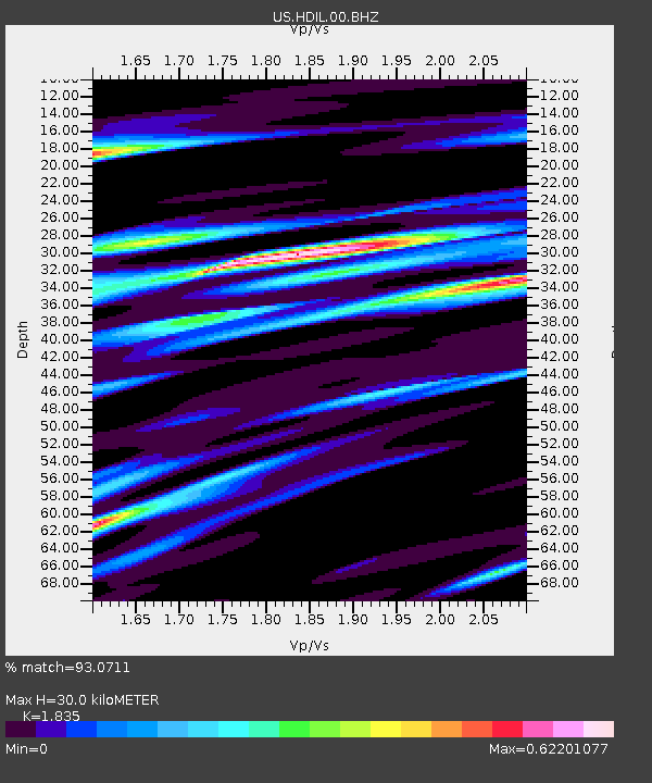
| Estimated Moho Depth: |
30.0 km |
| Estimated Crust Vp/Vs: |
1.84 |
| Assumed Crust Vp: |
6.498 km/s |
| Estimated Crust Vs: |
3.541 km/s |
| Estimated Crust Poisson's Ratio: |
0.29 |
|
| Radial Match: |
93.0711 % |
| Radial Bump: |
400 |
| Transverse Match: |
64.20385 % |
| Transverse Bump: |
400 |
| SOD ConfigId: |
558545 |
| Insert Time: |
2013-09-17 23:51:31.568 +0000 |
| GWidth: |
2.5 |
| Max Bumps: |
400 |
| Tol: |
0.001 |
|

Signal To Noise
| Channel | StoN | STA | LTA |
| US:HDIL:00:BHZ:20121116T18:23:41.373989Z | 17.977036 | 4.3512614E-6 | 2.4204556E-7 |
| US:HDIL:00:BH1:20121116T18:23:41.373989Z | 4.846589 | 1.6847496E-6 | 3.476155E-7 |
| US:HDIL:00:BH2:20121116T18:23:41.373989Z | 3.4682708 | 1.1974598E-6 | 3.4526136E-7 |
| Arrivals |
| Ps | 4.0 SECOND |
| PpPs | 13 SECOND |
| PsPs/PpSs | 17 SECOND |


