You are here: Home > Network List > US - United States National Seismic Network Stations List
> Station LAO LASA Array, Montana, USA > Earthquake Result Viewer
LAO LASA Array, Montana, USA - Earthquake Result Viewer
| Earthquake location: |
Kuril Islands |
| Earthquake latitude/longitude: |
49.3/155.4 |
| Earthquake time(UTC): |
2012/11/16 (321) 18:12:39 GMT |
| Earthquake Depth: |
29 km |
| Earthquake Magnitude: |
6.5 MW, 6.1 MB, 6.3 MS, 6.5 MW |
| Earthquake Catalog/Contributor: |
NEIC PDE/NEIC PDE-W |
|
| Network: |
US United States National Seismic Network |
| Station: |
LAO LASA Array, Montana, USA |
| Lat/Lon: |
46.69 N/106.22 W |
| Elevation: |
902 m |
|
| Distance: |
61.1 deg |
| Az: |
51.049 deg |
| Baz: |
312.284 deg |
| Ray Param: |
0.061022524 |
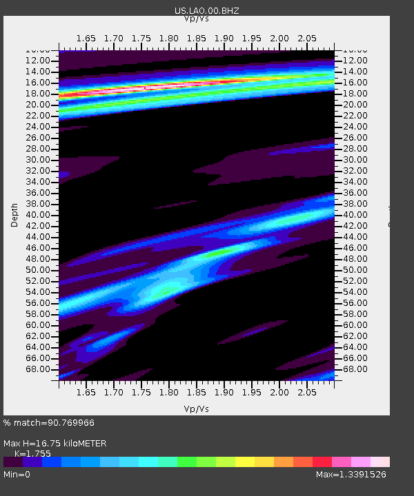
| Estimated Moho Depth: |
16.75 km |
| Estimated Crust Vp/Vs: |
1.75 |
| Assumed Crust Vp: |
6.438 km/s |
| Estimated Crust Vs: |
3.668 km/s |
| Estimated Crust Poisson's Ratio: |
0.26 |
|
| Radial Match: |
90.769966 % |
| Radial Bump: |
400 |
| Transverse Match: |
59.045246 % |
| Transverse Bump: |
400 |
| SOD ConfigId: |
558545 |
| Insert Time: |
2013-09-17 23:51:52.308 +0000 |
| GWidth: |
2.5 |
| Max Bumps: |
400 |
| Tol: |
0.001 |
|

Signal To Noise
| Channel | StoN | STA | LTA |
| US:LAO:00:BHZ:20121116T18:22:20.673977Z | 13.42088 | 4.334624E-6 | 3.2297612E-7 |
| US:LAO:00:BH1:20121116T18:22:20.673977Z | 0.7046075 | 4.3640233E-7 | 6.193552E-7 |
| US:LAO:00:BH2:20121116T18:22:20.673977Z | 2.4260242 | 1.083416E-6 | 4.4658086E-7 |
| Arrivals |
| Ps | 2.1 SECOND |
| PpPs | 6.8 SECOND |
| PsPs/PpSs | 8.9 SECOND |


