You are here: Home > Network List > II - Global Seismograph Network (GSN - IRIS/IDA) Stations List
> Station EFI Mount Kent, East Falkland Island > Earthquake Result Viewer
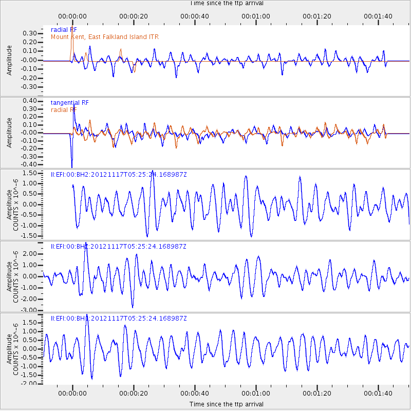
EFI Mount Kent, East Falkland Island - Earthquake Result Viewer
*The percent match for this event was below the threshold and hence no stack was calculated.
| Earthquake location: |
Tonga Islands Region |
| Earthquake latitude/longitude: |
-18.4/-172.3 |
| Earthquake time(UTC): |
2012/11/17 (322) 05:12:56 GMT |
| Earthquake Depth: |
10 km |
| Earthquake Magnitude: |
5.9 MW, 5.5 MS, 5.8 MB, 5.9 MW |
| Earthquake Catalog/Contributor: |
NEIC PDE/NEIC PDE-W |
|
| Network: |
II Global Seismograph Network (GSN - IRIS/IDA) |
| Station: |
EFI Mount Kent, East Falkland Island |
| Lat/Lon: |
51.68 S/58.06 W |
| Elevation: |
110 m |
|
| Distance: |
89.9 deg |
| Az: |
145.409 deg |
| Baz: |
239.972 deg |
| Ray Param: |
$rayparam |
*The percent match for this event was below the threshold and hence was not used in the summary stack. |
|
| Radial Match: |
51.748653 % |
| Radial Bump: |
368 |
| Transverse Match: |
37.351948 % |
| Transverse Bump: |
400 |
| SOD ConfigId: |
558545 |
| Insert Time: |
2013-09-17 23:56:33.587 +0000 |
| GWidth: |
2.5 |
| Max Bumps: |
400 |
| Tol: |
0.001 |
|
Signal To Noise
| Channel | StoN | STA | LTA |
| II:EFI:00:BHZ:20121117T05:25:24.168987Z | 2.5088975 | 1.3559596E-6 | 5.4046035E-7 |
| II:EFI:00:BH1:20121117T05:25:24.168987Z | 1.5255754 | 8.687249E-7 | 5.6944083E-7 |
| II:EFI:00:BH2:20121117T05:25:24.168987Z | 0.8131857 | 4.3064748E-7 | 5.2958075E-7 |
| Arrivals |
| Ps | |
| PpPs | |
| PsPs/PpSs | |


