You are here: Home > Network List > US - United States National Seismic Network Stations List
> Station LKWY Lake (Yellowstone--Lake), Wyoming, USA > Earthquake Result Viewer
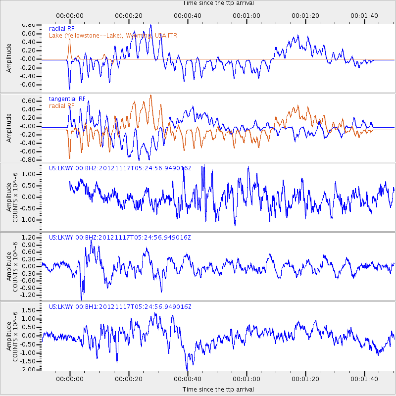
LKWY Lake (Yellowstone--Lake), Wyoming, USA - Earthquake Result Viewer
*The percent match for this event was below the threshold and hence no stack was calculated.
| Earthquake location: |
Tonga Islands Region |
| Earthquake latitude/longitude: |
-18.4/-172.3 |
| Earthquake time(UTC): |
2012/11/17 (322) 05:12:56 GMT |
| Earthquake Depth: |
10 km |
| Earthquake Magnitude: |
5.9 MW, 5.5 MS, 5.8 MB, 5.9 MW |
| Earthquake Catalog/Contributor: |
NEIC PDE/NEIC PDE-W |
|
| Network: |
US United States National Seismic Network |
| Station: |
LKWY Lake (Yellowstone--Lake), Wyoming, USA |
| Lat/Lon: |
44.57 N/110.40 W |
| Elevation: |
2424 m |
|
| Distance: |
84.2 deg |
| Az: |
39.336 deg |
| Baz: |
237.361 deg |
| Ray Param: |
$rayparam |
*The percent match for this event was below the threshold and hence was not used in the summary stack. |
|
| Radial Match: |
54.533215 % |
| Radial Bump: |
400 |
| Transverse Match: |
55.644287 % |
| Transverse Bump: |
400 |
| SOD ConfigId: |
558545 |
| Insert Time: |
2013-09-17 23:59:27.693 +0000 |
| GWidth: |
2.5 |
| Max Bumps: |
400 |
| Tol: |
0.001 |
|
Signal To Noise
| Channel | StoN | STA | LTA |
| US:LKWY:00:BHZ:20121117T05:24:56.949016Z | 3.0456393 | 4.9703243E-7 | 1.6319478E-7 |
| US:LKWY:00:BH1:20121117T05:24:56.949016Z | 1.0061074 | 4.0540957E-7 | 4.029486E-7 |
| US:LKWY:00:BH2:20121117T05:24:56.949016Z | 0.888488 | 2.90924E-7 | 3.2743716E-7 |
| Arrivals |
| Ps | |
| PpPs | |
| PsPs/PpSs | |


