You are here: Home > Network List > US - United States National Seismic Network Stations List
> Station MIAR Mount Ida, Arkansas, USA > Earthquake Result Viewer
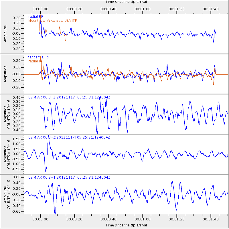
MIAR Mount Ida, Arkansas, USA - Earthquake Result Viewer
*The percent match for this event was below the threshold and hence no stack was calculated.
| Earthquake location: |
Tonga Islands Region |
| Earthquake latitude/longitude: |
-18.4/-172.3 |
| Earthquake time(UTC): |
2012/11/17 (322) 05:12:56 GMT |
| Earthquake Depth: |
10 km |
| Earthquake Magnitude: |
5.9 MW, 5.5 MS, 5.8 MB, 5.9 MW |
| Earthquake Catalog/Contributor: |
NEIC PDE/NEIC PDE-W |
|
| Network: |
US United States National Seismic Network |
| Station: |
MIAR Mount Ida, Arkansas, USA |
| Lat/Lon: |
34.55 N/93.58 W |
| Elevation: |
207 m |
|
| Distance: |
91.4 deg |
| Az: |
54.077 deg |
| Baz: |
248.687 deg |
| Ray Param: |
$rayparam |
*The percent match for this event was below the threshold and hence was not used in the summary stack. |
|
| Radial Match: |
67.87002 % |
| Radial Bump: |
400 |
| Transverse Match: |
67.459946 % |
| Transverse Bump: |
400 |
| SOD ConfigId: |
558545 |
| Insert Time: |
2013-09-17 23:59:29.691 +0000 |
| GWidth: |
2.5 |
| Max Bumps: |
400 |
| Tol: |
0.001 |
|
Signal To Noise
| Channel | StoN | STA | LTA |
| US:MIAR:00:BHZ:20121117T05:25:31.124004Z | 4.5909696 | 8.8854586E-7 | 1.9354209E-7 |
| US:MIAR:00:BH1:20121117T05:25:31.124004Z | 0.78485405 | 1.5001861E-7 | 1.9114205E-7 |
| US:MIAR:00:BH2:20121117T05:25:31.124004Z | 1.3969593 | 2.2836265E-7 | 1.6347123E-7 |
| Arrivals |
| Ps | |
| PpPs | |
| PsPs/PpSs | |


