You are here: Home > Network List > US - United States National Seismic Network Stations List
> Station NATX Nacogdoches, Texas, USA > Earthquake Result Viewer
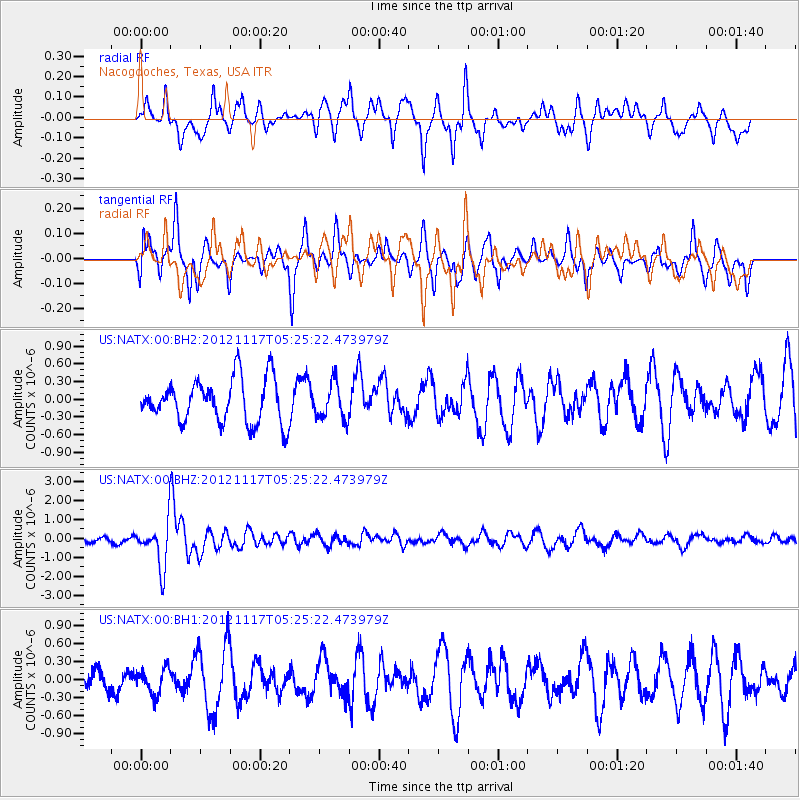
NATX Nacogdoches, Texas, USA - Earthquake Result Viewer
*The percent match for this event was below the threshold and hence no stack was calculated.
| Earthquake location: |
Tonga Islands Region |
| Earthquake latitude/longitude: |
-18.4/-172.3 |
| Earthquake time(UTC): |
2012/11/17 (322) 05:12:56 GMT |
| Earthquake Depth: |
10 km |
| Earthquake Magnitude: |
5.9 MW, 5.5 MS, 5.8 MB, 5.9 MW |
| Earthquake Catalog/Contributor: |
NEIC PDE/NEIC PDE-W |
|
| Network: |
US United States National Seismic Network |
| Station: |
NATX Nacogdoches, Texas, USA |
| Lat/Lon: |
31.76 N/94.66 W |
| Elevation: |
156 m |
|
| Distance: |
89.5 deg |
| Az: |
56.324 deg |
| Baz: |
248.08 deg |
| Ray Param: |
$rayparam |
*The percent match for this event was below the threshold and hence was not used in the summary stack. |
|
| Radial Match: |
53.227722 % |
| Radial Bump: |
390 |
| Transverse Match: |
68.30965 % |
| Transverse Bump: |
400 |
| SOD ConfigId: |
558545 |
| Insert Time: |
2013-09-17 23:59:43.174 +0000 |
| GWidth: |
2.5 |
| Max Bumps: |
400 |
| Tol: |
0.001 |
|
Signal To Noise
| Channel | StoN | STA | LTA |
| US:NATX:00:BHZ:20121117T05:25:22.473979Z | 7.5425544 | 1.1919494E-6 | 1.5802993E-7 |
| US:NATX:00:BH1:20121117T05:25:22.473979Z | 0.8928692 | 2.1870534E-7 | 2.4494668E-7 |
| US:NATX:00:BH2:20121117T05:25:22.473979Z | 0.8217198 | 3.0454575E-7 | 3.7061994E-7 |
| Arrivals |
| Ps | |
| PpPs | |
| PsPs/PpSs | |


