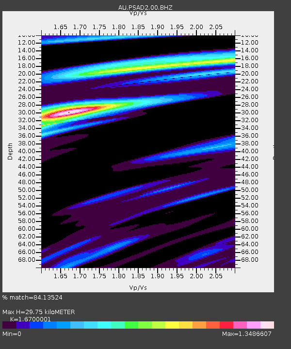
PSAD2 Pilbara Seismic Array Element D2 - Earthquake Result Viewer

Earthquake location: New Britain Region, P.N.G.
Earthquake latitude/longitude: -5.7/151.6
Earthquake time(UTC): 2012/11/19 (324) 09:44:34 GMT
Earthquake Depth: 13 km
Earthquake Magnitude: 5.9 MB, 5.9 MS, 6.0 MW, 5.9 MW
Earthquake Catalog/Contributor: WHDF/NEIC
Network: AU Australian Seismological Centre
Station: PSAD2 Pilbara Seismic Array Element D2
Lat/Lon: 21.62 S/119.96 E
Elevation: 366 m
Distance: 34.5 deg
Az: 239.611 deg
Baz: 67.295 deg
Ray Param: 0.07772206
Estimated Moho Depth: 29.75 km
Estimated Crust Vp/Vs: 1.67
Assumed Crust Vp: 6.464 km/s
Estimated Crust Vs: 3.87 km/s
Estimated Crust Poisson's Ratio: 0.22
Radial Match: 84.13524 %
Radial Bump: 352
Transverse Match: 58.746616 %
Transverse Bump: 400
SOD ConfigId: 558545
Insert Time: 2013-09-18 00:01:02.324 +0000
GWidth: 2.5
Max Bumps: 400
Tol: 0.001

Signal To Noise

ChannelStoNSTALTA
AU:PSAD2:00:BHZ:20121119T09:50:50.718999Z5.4616522.2094277E-64.0453475E-7
AU:PSAD2:00:BH1:20121119T09:50:50.718999Z5.9073461.5586762E-62.6385388E-7
AU:PSAD2:00:BH2:20121119T09:50:50.718999Z2.2966665.0383807E-72.1937804E-7
Arrivals
Ps3.4 SECOND
PpPs11 SECOND
PsPs/PpSs15 SECOND