You are here: Home > Network List > IU - Global Seismograph Network (GSN - IRIS/USGS) Stations List
> Station HNR Honiara, Solomon Islands > Earthquake Result Viewer
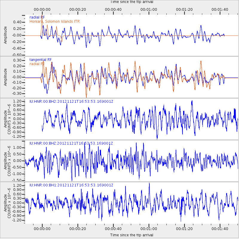
HNR Honiara, Solomon Islands - Earthquake Result Viewer
*The percent match for this event was below the threshold and hence no stack was calculated.
| Earthquake location: |
South Of Sumbawa, Indonesia |
| Earthquake latitude/longitude: |
-11.4/117.9 |
| Earthquake time(UTC): |
2012/11/21 (326) 16:46:40 GMT |
| Earthquake Depth: |
25 km |
| Earthquake Magnitude: |
5.8 MB, 5.1 MS, 5.4 MW, 5.3 MW |
| Earthquake Catalog/Contributor: |
WHDF/NEIC |
|
| Network: |
IU Global Seismograph Network (GSN - IRIS/USGS) |
| Station: |
HNR Honiara, Solomon Islands |
| Lat/Lon: |
9.44 S/159.95 E |
| Elevation: |
100 m |
|
| Distance: |
41.3 deg |
| Az: |
91.416 deg |
| Baz: |
263.536 deg |
| Ray Param: |
$rayparam |
*The percent match for this event was below the threshold and hence was not used in the summary stack. |
|
| Radial Match: |
57.643974 % |
| Radial Bump: |
400 |
| Transverse Match: |
71.98548 % |
| Transverse Bump: |
400 |
| SOD ConfigId: |
558545 |
| Insert Time: |
2013-09-18 00:03:53.014 +0000 |
| GWidth: |
2.5 |
| Max Bumps: |
400 |
| Tol: |
0.001 |
|
Signal To Noise
| Channel | StoN | STA | LTA |
| IU:HNR:00:BHZ:20121121T16:53:53.169001Z | 1.9408216 | 5.898756E-7 | 3.0393088E-7 |
| IU:HNR:00:BH1:20121121T16:53:53.169001Z | 0.82089853 | 2.6606637E-7 | 3.24116E-7 |
| IU:HNR:00:BH2:20121121T16:53:53.169001Z | 0.76334196 | 3.0694895E-7 | 4.0211197E-7 |
| Arrivals |
| Ps | |
| PpPs | |
| PsPs/PpSs | |


